
File:Deepwater Horizon oil spill fishing closure map 2010-06-21.png
| |
This is a file from the Wikimedia Commons. Information from its description page there is shown below.
Commons is a freely licensed media file repository. You can help. |
Summary
| Description |
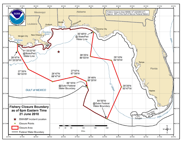
English: Map entitled "Fishery Closure Boundary as of 6pm Eastern Time 21 June 2010" due to the Deepwater Horizon oil spill, extending from Atchafalaya Bay, Louisiana to Panama City, Florida
|
|||
| Date | 21 June 2010 | |||
| Source | http://sero.nmfs.noaa.gov/sf/deepwater_horizon/BP_OilSpill_FisheryClosureMap_062110.png | |||
| Author | U. S. National Oceanic and Atmospheric Administration | |||
| Permission ( Reusing this file) |
|
As of 21 June 2010 the "closure measures 86,985 sq mi (225,290 sq km) and covers about 36% of the Gulf of Mexico exclusive economic zone." SOURCE: http://sero.nmfs.noaa.gov/bulletins/pdfs/2010/FB10-055_BP_Oil_Spill_Closure_062110.pdf
See chronological table of changes in the size and percentage of Federal waters closed to fishing since 2 May 2010 in "Deepwater Horizon/BP Oil Spill: Size and Percent Coverage of Fishing Area Closures Due to BP Oil Spill" at http://sero.nmfs.noaa.gov/ClosureSizeandPercentCoverage.htm
Licensing
 |
This image is in the public domain because it contains materials that originally came from the U.S. National Oceanic and Atmospheric Administration, taken or made as part of an employee's official duties.
|
 |
File usage
Learn more
SOS Children aims to make Wikipedia suitable for young learners. SOS Childrens Villages helps more than 2 million people across 133 countries around the world. If you'd like to help, why not learn how to sponsor a child?