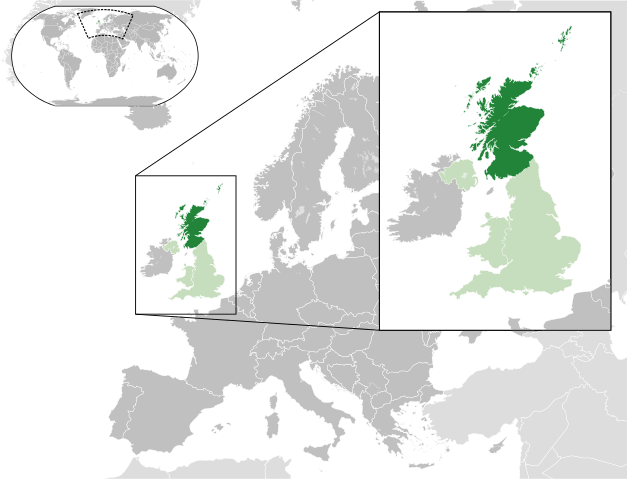
File:Scotland in the UK and Europe.svg

Size of this preview: 627 × 479 pixels.
| |
This is a file from the Wikimedia Commons. Information from its description page there is shown below.
Commons is a freely licensed media file repository. You can help. |
Summary
| DescriptionScotland in the UK and Europe.svg |
English: A map of Scotland within the United Kingdom and Europe. The map is a polar orthographic projection.
Scotland
United Kingdom (except Scotland)
Europe (except UK)
Español: Un mapa de Escocia en el Reino Unido y Europa. El mapa es una proyección ortogonal polar.
Escocia
Reino Unido (excepto Escocia)
Europa (excepto RU)
Français : Une carte de l'Ecosse au sein du Royaume-Uni et en Europe. La carte est un polair projection orthographique.
Écosse
Royaume-Unie (sauf l'Écosse)
Europe (sauf le Royaume-Unie)
Deutsch: Eine Karte der Schottland drinnen das Vereinigtes Königreich und drinnen Europa. Die Karte ist ein polare orthografische Azimutalprojektion.
Schottland
Vereinigtes Königreich (außer Schottland)
Europa (außer das Vereinigtes Königreich)
Cymraeg:
Yr Alban
Y Deyrnas Unedig
Ewrop
Gàidhlig:
Alba
An Rìoghachd Aonaichte
An Roinn-Eòrpa
Gaeilge:
Albain
An Ríocht Aontaithe
An Eoraip
|
| Date | 2012-02-25 22:33 (UTC) |
| Source | This file was derived from: |
| Author |
|
Licensing
| This file is licensed under the Creative Commons Attribution-Share Alike 3.0 Unported license. | ||
http://creativecommons.org/licenses/by-sa/3.0 CC-BY-SA-3.0 Creative Commons Attribution-Share Alike 3.0 truetrue |
File usage
The following pages on Schools Wikipedia link to this image (list may be incomplete):
Metadata
This file contains additional information, probably added from the digital camera or scanner used to create or digitize it. If the file has been modified from its original state, some details may not fully reflect the modified file.
| Short title | Scotland within the UK and Europe |
|---|---|
| Image title | Map of Scotland within the United Kingdom of Great Britain and Northern Ireland, and within Europe. Released under Creative Commons Attribution-Share Alike 3.0 Unported ( http://creativecommons.org/licenses/by-sa/3.0/). Based upon http://commons.wikimedia.org/wiki/File:Blank_map_of_Europe.svg; licence and details below: A blank Map of Europe. Every country has an id which is its ISO-3166-1-ALPHA2 code in lower case. Members of the EU have a class="eu", countries in europe (which I found turkey to be but russia not) have a class="europe". Certain countries are further subdivided the United Kingdom has gb-gbn for Great Britain and gb-nir for Northern Ireland. Russia is divided into ru-kgd for the Kaliningrad Oblast and ru-main for the Main body of Russia. There is the additional grouping #xb for the "British Islands" (the UK with its Crown Dependencies - Jersey, Guernsey and the Isle of Man) Contributors. Original Image: ( http://commons.wikimedia.org/wiki/Image:Europe_countries.svg) Júlio Reis ( http://commons.wikimedia.org/wiki/User:Tintazul). Recolouring and tagging with country codes: Marian "maix" Sigler ( http://commons.wikimedia.org/wiki/User:Maix) Improved geographical features: http://commons.wikimedia.org/wiki/User:W!B: Updated to reflect dissolution of Serbia & Montenegro: http://commons.wikimedia.org/wiki/User:Zirland Updated to include British Crown Dependencies as seperate entities and regroup them as "British Islands", with some simplifications to the XML and CSS: James Hardy ( http://commons.wikimedia.org/wiki/User:MrWeeble) Validated ( http://commons.wikimedia.org/wiki/User:CarolSpears) Changed the country code of Serbia to RS per http://en.wikipedia.org/wiki/Serbian_country_codes and the file http://www.iso.org/iso/iso3166_en_code_lists.txt ( http://commons.wikimedia.org/wiki/User:TimothyBourke) Uploaded on behalf of User:Checkit, direct complaints to him plox: 'Moved countries out of the "outlines" group, removed "outlines" style class, remove separate style information for Russia' ( http://commons.wikimedia.org/wiki/User:Collard) Updated various coastlines and boarders and added various islands not previously shown (details follow). Added Kosovo and Northern Cyprus as disputed territories. Moved major lakes to their own object and added more. List of updated boarders/coastlines: British Isles (+ added Isle of Wight, Skye, various smaller islands), the Netherlands, Germany, Czech Republic, Denmark, Sweden, Finland, Poland, Kaliningrad Oblast of the Russian Federation (and minor tweaks to Lithuania), Ukraine, Moldova (minor), Romania, Bulgaria, Turkey, Greece, F.Y.R. Macedonia, Serbia, Bosnia and Herzegovina, Montenegro, Albania, Croatia, Italy (mainland and Sicily), Malta ( http://commons.wikimedia.org/wiki/User:Alphathon). Added Bornholm ( http://commons.wikimedia.org/wiki/User:Heb)
|
| Width | 680 |
| Height | 520 |
What is Schools Wikipedia?
This selection has made Wikipedia available to all children. SOS Children's Villages helps those who have nothing and no one, giving them back the famly they have lost and bringing them the very best opportunities for a happy, healthy future. We have helped children in Africa for many years - you can help too...
