
File:Vehicles map 2001-2007.gif
Size of this preview: 640 × 287 pixels.
| |
This is a file from the Wikimedia Commons. Information from its description page there is shown below.
Commons is a freely licensed media file repository. You can help. |
Summary
| Description |
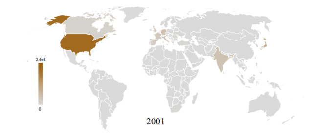
English: Political world map shaded according to the number of vehicles in use in each country and spanning the years 2001-2007. Data is from Wolfram Alpha's international transportation data that includes:
-European Commission. "Transport." Statistics. -International Road Federation. World Road Statistics. -United States Department of Transportation. "Highway Statistic Series." Federal Highway Administration. -United States Department of Transportation. "National Transportation Statistics." Research and Innovative Technology Administration. |
| Date | 5 June 2012 |
| Source | Own work |
| Author | Michael Hale |
Licensing
|
File usage
The following pages on Schools Wikipedia link to this image (list may be incomplete):
Metadata
More information
Schools Wikipedia was launched to make learning available to everyone. SOS Children's Villages is a global charity founded in 1949 to give children who have lost everything the childhood they deserve. Have you thought about sponsoring a child?