 |
This is a file from the Wikimedia Commons. Information from its description page there is shown below.
Commons is a freely licensed media file repository. You can help.
|
| Description |
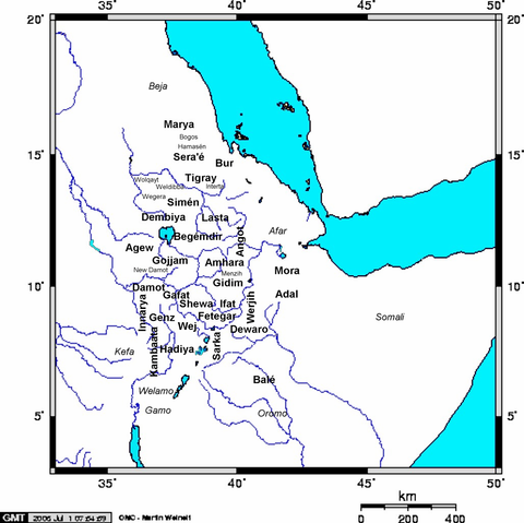
English: Created by me ( Yom). Map of Medieval Ethiopian provinces in large bold lettering, sub-provinces in small lettering, and neighboring tribes in italics (not part of Ethiopia in Medieval times - some may have had their own kingdoms).
|
| Date |
3 July 2006 (first version); 3 July 2006 (last version) |
| Source |
Transferred from en.wikipedia |
| Author |
Original uploader was Yom at en.wikipedia |
Permission
( Reusing this file) |
CC-BY-SA-3.0-MIGRATED; Released under the GNU Free Documentation License.
|
Licensing
Yom at the English language Wikipedia, the copyright holder of this work, hereby publishes it under the following license:
 |
Permission is granted to copy, distribute and/or modify this document under the terms of the GNU Free Documentation License, Version 1.2 or any later version published by the Free Software Foundation; with no Invariant Sections, no Front-Cover Texts, and no Back-Cover Texts.
Subject to disclaimers.www.gnu.org/copyleft/fdl.htmlGFDLGNU Free Documentation Licensetruetrue
|
|
File usage
The following pages on Schools Wikipedia link to this image (list may be incomplete):
Schools Wikipedia was launched to make learning available to everyone. Thanks to SOS Children's Villages, 62,000 children are enjoying a happy childhood, with a healthy, prosperous future ahead of them. You can help by sponsoring a child.


