 |
This is a file from the Wikimedia Commons. Information from its description page there is shown below.
Commons is a freely licensed media file repository. You can help.
|
| Description |
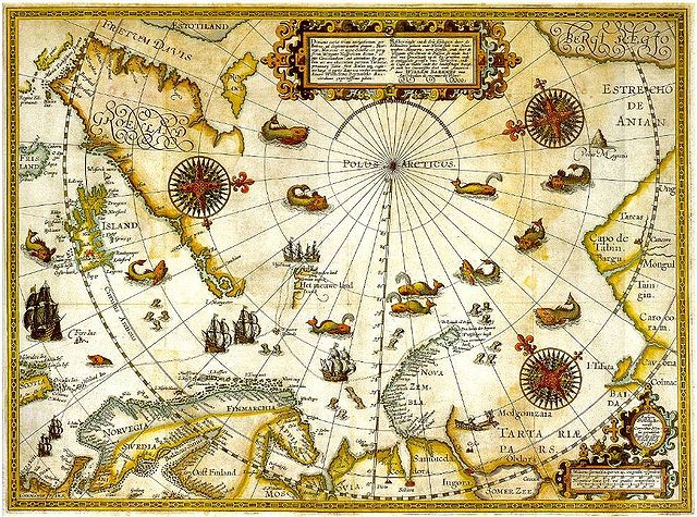
Portion of 1599 map of Arctic exploration by Willem Barentsz. Spitsbergen, here mapped for the first time, is indicated as "Het Nieuwe Land" (Dutch for "the New Land"), centre-left. |
| Date |
Original map 1599. Portion published online by Tromsø University 1999 as part of the "Northern Lights Route" project of the Council of Europe. Uploaded to Commons 2006. |
| Source |
University Library of Tromsø |
| Author |
Willem Barentsz. |
Permission
( Reusing this file) |
Public domain (over 70 years since creator's death)
|
Licensing
| Public domainPublic domainfalsefalse |
 |
This image (or other media file) is in the public domain because its copyright has expired.
This applies to Australia, the European Union and those countries with a copyright term of life of the author plus 70 years.
 You must also include a United States public domain tag to indicate why this work is in the public domain in the United States. Note that a few countries have copyright terms longer than 70 years: Mexico has 100 years, Colombia has 80 years, and Guatemala and Samoa have 75 years, Russia has 74 years for some authors. This image may not be in the public domain in these countries, which moreover do not implement the rule of the shorter term. Côte d'Ivoire has a general copyright term of 99 years and Honduras has 75 years, but they do implement the rule of the shorter term. You must also include a United States public domain tag to indicate why this work is in the public domain in the United States. Note that a few countries have copyright terms longer than 70 years: Mexico has 100 years, Colombia has 80 years, and Guatemala and Samoa have 75 years, Russia has 74 years for some authors. This image may not be in the public domain in these countries, which moreover do not implement the rule of the shorter term. Côte d'Ivoire has a general copyright term of 99 years and Honduras has 75 years, but they do implement the rule of the shorter term.
|
|
This file has been identified as being free of known restrictions under copyright law, including all related and neighboring rights.
|
File usage
The following pages on Schools Wikipedia link to this image (list may be incomplete):
Wikipedia for Schools brings Wikipedia into the classroom. By supporting vulnerable children right through to adulthood, SOS Children makes a lasting difference to the lives of thousands of people. Education is a key part of our work, and our schools provide high-quality teaching to the children in our care. Would you like to sponsor a child?


