
File:East-Hem 400ad.jpg
| |
This is a file from the Wikimedia Commons. Information from its description page there is shown below.
Commons is a freely licensed media file repository. You can help. |
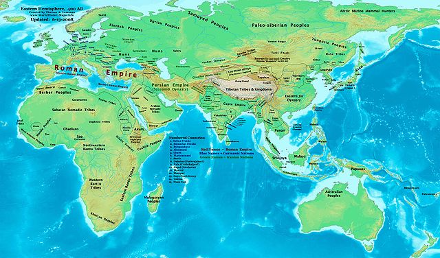
| Description | Eastern Hemisphere in 400 AD. | ||||||
| Date | |||||||
| Source | self-made (For reference information, see the Map Source References section below.) | ||||||
| Author | Thomas Lessman ( Contact!) | ||||||
| Permission ( Reusing this file) |
|
Map Summary
Original Source URL: http://www.thomaslessman.com/History/images/East-Hem_400ad.jpg.
This map of the Eastern Hemisphere in 400 AD was created by Thomas Lessman, based on information from the sources listed below. This map is free for educational use (see Permission info above). When using this map, please mention that it is available for free at www.WorldHistoryMaps.info.
Map Source References
- Remember, sources often conflict with each other. This map is only as accurate as the information that is available to me. To report any errors or to help further this work, please click here, or email Thomas Lessman at talessman@yis.us
Source References for information contained in this map:
Primary Sources for East-Hem_400ad.jpg:
- 1. The DK Atlas of World History, 2000 Edition (See specific references below).
- 2. WorldHistoryMaps.com's maps of the Countries of the World, 1-1-386.
- 3. Wikimedia's World Map 400 CE, made by User:Javierfv1212, and Wikipedia articles (noted below).
I - African Information
Note: Most of the African Information I have for 400 AD comes from The DK Atlas of World History map of The Development of Complex Societies in Africa; (Pg 160).
- (Bantus, Berber Tribes, Chadians, Cushites, Daamat, Garamantes, Gur, Khoisan Peoples, Kwa, Libyans, Mandes, Nilotic Peoples, West Atlantic Peoples)
II - Asian Information is derived from these sources:
- Arabian Tribal Locations are derived from this map of 5th century Arabia, from www.MidEastWeb.org.
- Caucasian borders are from the map of Europe in 400 AD on Euratlas.com.
- (Albania, Iberia, Lazica, and Persarmenia, etc.)
- China's Eastern Jin Dynasty borders are derived from:
- 1. The DK Atlas of World History map of The Later 16 Kingdoms period, c. 400 CE, (Pg 261)
- 2. The WorldHistoryMaps.com map of the Countries of the World, 1-1-386.
- Funan borders are derived from:
- 1. The DK Atlas of World History, 2000 Edition; map of The World in 250 CE, (Pg 46-47).
- 2. Wikipedia's article about Funan, along with this map of Funan in 001, uploaded by User:L_joo.
- Indian Information is derived from:
- 1. Comparison of WorldHistoryMaps.com's maps of the Countries of the World in 386 and 420 CE. (Note: The 386 map is available for free on their sample page. The 420 CE map is available only to paid accounts.)
- 2. This map of Gupta Expansion, from "The World: Grand Atlas of History" by SA Ebisa, put online by the Imperial Maps website (in Spanish).
- 3. Any information missing from the maps listed above is covered in Wikipedia articles on the countries depicted.
- Japanese information is derived from the DK Atlas of World History, 2000 Edition; map of State Formation in Korea & Japan to 650 CE; (Pg 264)
- Kidarite and Kushansha borders are derived from the WorldHistoryMaps.com map of the Countries of the World in 386 CE. (Note: These maps show Kidarites as Kingdom of Gandhara and Taxila.)
- Korean and Manchurian information comes from this map of the History_of_Korea-375.png, created by User:Historiographer.
- Malay Kingdoms and peoples are derived from The DK Atlas of World History, 2000 Edition; map of "Areas influenced by India in SE Asia to 650 CE"; (Pg 241)
- Rouran or Juan-Juan information is from the History & Commercial Atlas of China, map of Asia in 440 AD, available on Huhai.net, along with Wikipedia's article about the Rouran and its first two Khagans.
- Sassanid Persian Empire borders are derived from:
- 1. Eastern Sassanid borders are based on the WorldHistoryMaps.com map of the Countries of the World in 386 CE.
- 2. Western Sassanid borders are based on the Euratlas.com map of Europe in 400 AD.
- Turks, Yueban, & Gaoche locations come from:
- 1. The History & Commercial Atlas of China, map of Asia in 440 AD, available on Huhai.net.
- 2. Wikipedia's articles about the Yueban state, the Dingling (aka Gaoche), and the Göktürks.
III - European Information is mostly derived from the Euratlas.com map of Europe in 400 AD.
IV - Australia, Siberia, & Other Fringe Information is derived from:
- 1. Wikimedia's map of the World Map 400 CE, made by User:Javierfv1212.
- 2. Comparison of The DK Atlas of World History maps of The World in 250 CE (Pg 47) and The World in 500 CE (Pg 51).
Note: Much of the information in this map was cross-checked with Bruce Gordon's Regnal Chronologies
Other Maps by Thomas Lessman
| Maps of the eastern hemisphere showing history Bold dates are available on Wikimedia or Wikipedia. |
||
| Primeval |
·| 1300 BC | 1000 BC | 625 BC | |
|
|
|
||
| Ancient BC / BCE
AD / CE |
·| 600 BC | 550 BC | 527 BC | 500 BC | 400 BC | ·| 1 AD | 50 AD | 100 AD | 200 AD | 300 AD | |
|
| Medieval |
·| 500 AD | 565 AD | 600 AD | 700 AD | |
|
| Modern |
·| 1500 AD | · * For historical maps of the whole world, |
|
File usage
What is Schools Wikipedia?
SOS Childrens Villages chose the best bits of Wikipedia to help you learn. SOS Children is there for the children in our care until they are ready for independence. There are many ways to help with SOS Children.