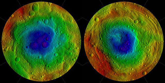
File:Vesta northern and southern hemispheres pia15677.jpg

Summary
| Description |
Relief map of the northern and southern hemispheres of 4 Vesta Original caption: This image from NASA's Dawn mission shows the topography of the northern and southern hemispheres of the giant asteroid Vesta, updated with pictures obtained during Dawn's last look back. Around the time of Dawn's departure from Vesta in the late summer of 2012, dawn was beginning to creep over the high northern latitudes, which were dark when Dawn arrived in the summer of 2011. These color-shaded relief maps show the northern and southern hemispheres of Vesta, derived from images analysis. Colors represent distance relative to Vesta's center, with lows in violet and highs in red. In the northern hemisphere map on the left, the surface ranges from lows of minus 13.82 miles (22.24 kilometers) to highs of 27.48 miles (44.22 kilometers). Light reflected off the walls of some shadowed craters at the north pole (in the centre of the image) was used to determine the height. In the southern hemisphere map on the right, the surface ranges from lows of minus 23.65 miles (38.06 kilometers) to 26.61 miles (42.82 kilometers). The shape model was constructed using images from Dawn's framing camera that were obtained from July 17, 2011, to Aug. 26, 2012. The data have been stereographically projected on a 300-mile-diameter (500-kilometer-diameter) sphere with the poles at the centre. The three craters that make up Dawn's "snowman" feature can be seen at the top of the northern hemisphere map on the left. A mountain more than twice the height of Mount Everest, inside the largest impact basin on Vesta, can be seen near the centre of the southern hemisphere map on the right. |
|---|---|
| Source |
http://dawn.jpl.nasa.gov/multimedia/imageoftheday/image.asp?date=20120911 |
| Date |
September 11, 2012 |
| Author |
NASA/ JPL |
| Permission ( Reusing this file) |
See below.
|
Licensing
 |
This is a candidate to be copied to Wikimedia Commons. Freely licensed or public domain media are more accessible to other Wikimedia projects if placed on Commons. Any user may perform this move—please see Moving images to the Commons for more information. Please thoroughly review the copyright status of this file and ensure that it is actually eligible for transfer to Commons. If you are concerned that this file could have problems with its attribution information and/or copyright status, then remove this notice and DO NOT transfer it to Commons. By transferring this file to Commons, you acknowledge you have read this message and are willing to accept any and all consequences for inappropriate transfers. Repeat violators will be blocked from editing. If you have checked the file and it is OK to move to Commons add "|human=username" to the template so other users can see it has been checked and can help you copy the file to Commons. If the file has already been moved to Commons, then consider nominating the file for deletion or changing the template to {{Already moved to Commons}} If the file can't be moved to Commons because it doesn't fit Common's scope, then use {{Do not move to Commons|reason=Why it can't be moved to Commons}} If you think that a local copy of this file should be kept, then use {{Keep local}}. Consider using {{Keep local|reason=Why the English Wikipedia needs a local copy}} Copy to Commons: via CommonsHelper |
||
|
|||
File usage
What is Schools Wikipedia?
SOS Childrens Villages aims to make Wikipedia suitable for young learners. The world's largest orphan charity, SOS Children brings a better life to more than 2 million people in 133 countries around the globe. Will you help another child today?

