 |
This is a file from the Wikimedia Commons. Information from its description page there is shown below.
Commons is a freely licensed media file repository. You can help.
|
Summary
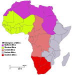
Africa: subregions as delineated by United Nations geographic classification scheme:
Northern Africa
-
physiographically, country with partial territory in Western Asia – Egypt ( Sinai Peninsula)
Western Africa
Central Africa
Eastern Africa
Southern Africa
Licensing
I, the copyright holder of this work, hereby publish it under the following licenses:
 |
Permission is granted to copy, distribute and/or modify this document under the terms of the GNU Free Documentation License, Version 1.2 or any later version published by the Free Software Foundation; with no Invariant Sections, no Front-Cover Texts, and no Back-Cover Texts. A copy of the license is included in the section entitled GNU Free Documentation License. http://www.gnu.org/copyleft/fdl.htmlGFDLGNU Free Documentation Licensetruetrue
|
You may select the license of your choice.
|
 |
File:Africa map regions.svg is a vector version of this file.
It should be used in place of this raster image when superior.
File:Africa-regions.png  File:Africa map regions.svg
For more information about vector graphics, read about Commons transition to SVG.
There is also information about MediaWiki's support of SVG images.
|
|
File usage
The following pages on Schools Wikipedia link to this image (list may be incomplete):
All five editions of Schools Wikipedia were compiled by SOS Children's Villages. Thanks to SOS Children's Villages, 62,000 children are enjoying a happy childhood, with a healthy, prosperous future ahead of them. Have you heard about child sponsorship? Visit our web site to find out.


