
File:Alexander-Empire 323bc.jpg
| |
This is a file from the Wikimedia Commons. Information from its description page there is shown below.
Commons is a freely licensed media file repository. You can help. |
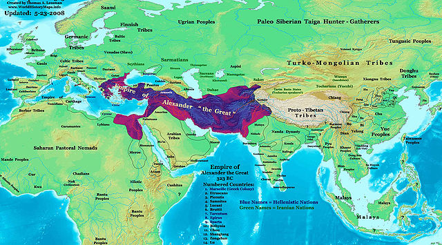
| Description | The Empire of Alexander the Great in 323 BC. | ||||||
| Date | 30 January 2008 | ||||||
| Source | Own work | ||||||
| Author | Thomas Lessman ( Contact!) | ||||||
| Permission ( Reusing this file) |
|
Contents |
Map Summary

Original Source URL: http://www.thomaslessman.com/History/images/East-Hem_001ad.jpg
This map is a zoomed-in version of Thomas Lessman's map of the East-Hem_323bc.jpg (also available at www.WorldHistoryMaps.info).
The highlighted areas represent the Empire of Alexander the Great at his death in 323 BC.
Map Source References
Remember, sources often conflict with each other. This map is only as accurate as the information that is available to me. To report any errors or to help further this work, please click here, or email Thomas Lessman at talessman@yis.us
References for information contained in this map:
- See the source info for East-Hem 323bc.jpg
Other Maps by Thomas Lessman
| Maps of the eastern hemisphere showing history Bold dates are available on Wikimedia or Wikipedia. |
||
| Primeval |
·| 1300 BC | 1000 BC | 625 BC | |
|
|
|
||
| Ancient BC / BCE
AD / CE |
·| 600 BC | 550 BC | 527 BC | 500 BC | 400 BC | ·| 1 AD | 50 AD | 100 AD | 200 AD | 300 AD | |
|
| Medieval |
·| 500 AD | 565 AD | 600 AD | 700 AD | |
|
| Modern |
·| 1500 AD | · * For historical maps of the whole world, |
|
Other Info
Licensing
|
File usage
Want to know more?
All five editions of Schools Wikipedia were compiled by SOS Children. In 133 nations around the world, SOS Children's Villages works to bring better education and healthcare to families in desperate need of support. There are many ways to help with SOS Childrens Villages.