Checked content

File:Piles of Salt Salar de Uyuni Bolivia Luca Galuzzi 2006 a.jpg
POTY
Cscr-featured.svg

Wikimedia CommonsWikipedia

This file was a finalist in Picture of the Year 2007.
This is a featured picture on Wikimedia Commons ( Featured pictures) and is considered one of the finest images.
Video-display-wide.svgSound-icon-empty.svgWith an aspect ratio of 8:5, 16:10, or 16:9, this image is suitable as a widescreen computer wallpaper (see gallery).


If you have an image of similar quality that can be published under a suitable copyright license, be sure to upload it, tag it, and nominate it.


Picture of the day

This image was selected as picture of the day on Wikimedia Commons for 19 June 2007. It was captioned as follows:

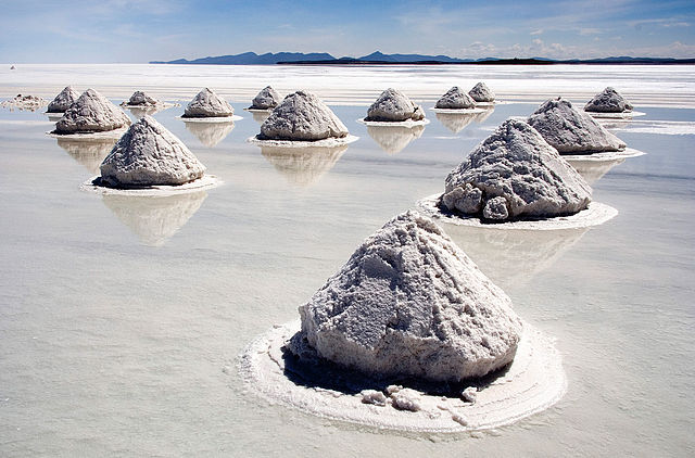
English: Salt mounds in Salar de Uyuni, Bolivia. (Photo: Luca Galuzzi - http://www.galuzzi.it)
Description
English: Salt mounds in Salar de Uyuni, Bolivia. The Salar de Uyuni is the world's largest (12 000 km²) and highest (3 700 m) salt flat, ca. 25 times as large as the Bonneville Salt Flats. It's the remnant of a prehistoric lake surrounded by mountains without drainage outlets. Salt is harvested in the traditional method: the salt is scraped into small mounds for water evaporation and easier transportation, dried over fire, and finally enriched with iodine.
Français : Récolte du sel dans le Salar de Uyuni, en Bolivie. Le Salar de Uyuni (3 700 m) couvre une surface de 12 000 km² soit la taille de l'Île-de-France, ce qui en fait le désert de sel le plus grand et le plus élevé du monde. Ce désert résulte de l'assèchement d'un lac préhistorique entouré de montagnes et privé d'émissaire. La récolte du sel se fait de façon traditionelle : le sel récolté est façonné en monticules, ce qui favorise l'évaporation de l'eau qu'il contient, et facilite son transport. Le sel est ensuite séché au feu, et enfin enrichi en iode.
Italiano: Raccolta del sale nel Salar de Uyuni, Bolivia. Il Salar de Uyuni è il più grande (12.000 km²) e più in alto (3.700 m) deserto di sale del mondo, con una superficie più estesa dell' Abruzzo. Deriva dal prosciugamento di un lago salato preistorico circondato dalle montagne e senza drenaggio. Il sale viene raccolto in modo tradizionale, accumulato in piccole montagnette in modo che l'acqua evapori poi viene asciugato sul fuoco e arricchito con iodio.
Deutsch: Salzhügel im Salar de Uyuni in Bolivien. Der Salar de Uyuni ist der größte (12.000 km²) und höchste (3700m) Salzsee der Welt, ungefähr 25 mal so groß wie die Bonneville Salt Flats. Er ist entstanden aus einem durch Berge eingeschlossenen prähistorischen See ohne Abfluß. Salz wird in der traditionellen Methode gewonnen: Das Salz wird zu kleinen Hügeln zusammengerecht zur Wasserevaporation und zum leichteren Transport, danach wird es über Feuer getrocknet und mit Jod angereichert.
Español: Pilas de sal en el Salar de Uyuni ( Bolivia), la mayor salina del mundo. Es el remanente de un lago prehistórico rodeado por montañas sin salidas de drenaje. La sal se cosecha con el método tradicional: se amontona enpequeñas pilas para que se evapore el agua y para transportarla fácilmente, secada al fuego, y enriquecida finalmente con yodo.
日本語: ボリビア、 ウユニ塩湖の製塩用の塩の山。ここでは湖の塩を削り取り小山を作って乾燥させるという伝統的手法で塩が生産されている。ウユニ塩湖は世界で最も大きく、最も標高の高い塩類平原で (12 000 km²、3 700 m)、 ボンネビル・ソルトフラッツの約25倍の大きさにあたる。
Türkçe: Bolivya'da bulunan ve Dünya'nın en büyük tuz göllerinden biri olan Salar de Uyuni'deki tuz tepecikleri.
Date 2006-04-14
Source Photo taken by ( Luca Galuzzi) * http://www.galuzzi.it
Author Luca Galuzzi ( Lucag), edit by Trialsanderrors
Permission
( Reusing this file)
USA 10096-7-8 HDR Antelope Canyon Luca Galuzzi 2007.jpg This Photo was taken by LucaG.

Please credit this: Luca Galuzzi - www.galuzzi.it in the immediate vicinity of the image.

If you use one of my photos, please email me (account needed) or leave me a short message on my discussion page.
It would be greatly appreciated. You can find more pictures on my Image Gallery...
Do not copy this image illegally by ignoring the terms of the license below, as it is not in the public domain.
If you would like special permission to use, license, or purchase the image please contact me to negotiate terms.

I, the copyright holder of this work, hereby publish it under the following license:
w:en:Creative Commons
attribution share alike
This file is licensed under the Creative Commons Attribution-Share Alike 2.5 Generic license.
You are free:
  • to share – to copy, distribute and transmit the work
  • to remix – to adapt the work
Under the following conditions:
  • attribution – You must attribute the work in the manner specified by the author or licensor (but not in any way that suggests that they endorse you or your use of the work).
  • share alike – If you alter, transform, or build upon this work, you may distribute the resulting work only under the same or similar license to this one.

Camera location

20° 19′ 0.00″ S, 66° 59′ 0.00″ W

This and other images at their locations on: Google Maps - Google Earth - OpenStreetMap ( Info)

Modifications for Wikipedia

  • Tilt corrected (skewed vertically 12px, cropped)
  • Background noise reduced (1px median, faded 40% normal with gradient tool)
  • Green fringe removed
The following pages on Schools Wikipedia link to this image (list may be incomplete):

Metadata

Schools Wikipedia and SOS Children

Through Schools Wikipedia, SOS Children has brought learning to children around the world. SOS Childrens Villages is an international children's charity, providing a good home and loving family to thousands of children who have lost their parents. We also work with communities to help vulnerable families stay together and raise children in the best possible environment. There are many ways to help with SOS Childrens Villages.