 |
This is a file from the Wikimedia Commons. Information from its description page there is shown below.
Commons is a freely licensed media file repository. You can help.
|
Summary
| Description |
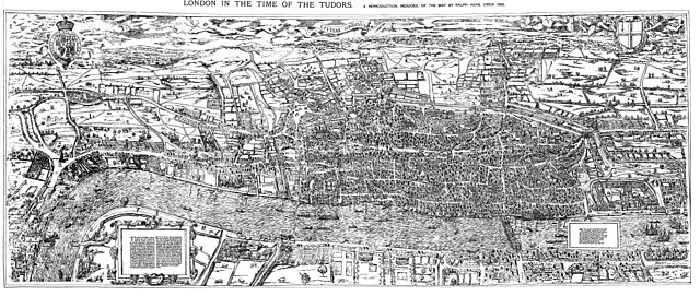
English: The earliest proper map (as opposed to panorama) of London known. Attributed to Ralph Agas, and probably surveyed between 1570 and 1605. The original was 6 foot 0.5 inches long by 2 feet 4.5 inches wide. This much reduced image is a scan of a copy of a lithograph of a copy, was itself badly repaired with sellotape and has had to be "restored"; so is hardly a truly faithful representation of the original, but few good copies exist and no other detailed public domain images are known.
|
| Date |
14 August 2009 |
| Source |
Maps of Old London, London, Adam and Charles Black, 1908. Scanned & corrected Mike Calder. |
| Author |
Mike Calder, image of Civitas Londinium, Agas' Map of London, c. 1570-1605 |
Licensing
| Public domainPublic domainfalsefalse |
 |
This work is in the public domain in the United States, and those countries with a copyright term of life of the author plus 100 years or less. |
|
This file has been identified as being free of known restrictions under copyright law, including all related and neighboring rights.
|
File usage
The following pages on Schools Wikipedia link to this image (list may be incomplete):
Through Schools Wikipedia, SOS Childrens Villages has brought learning to children around the world. Thanks to SOS Children, 62,000 children are enjoying a happy childhood, with a healthy, prosperous future ahead of them. Sponsoring a child is a great way to help children who need your support.


