
File:USGS map at 30 deg N lat, 105 deg E long (2008-05-18).png
| |
This is a file from the Wikimedia Commons. Information from its description page there is shown below.
Commons is a freely licensed media file repository. You can help. |
move approved by: User:LERK
This image was moved from Image:USGS map at 30°N,105°E (2008-05-18).png
| Description |
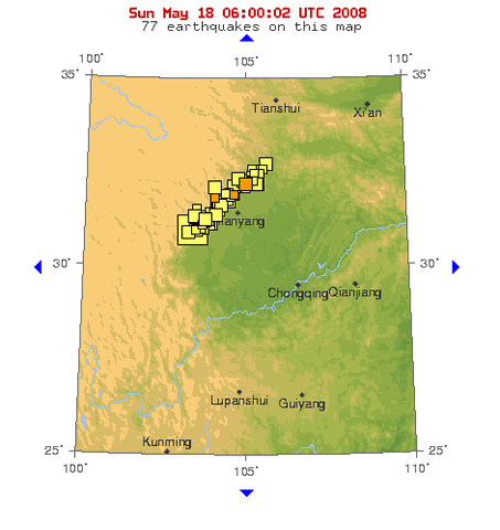
USGS map at 30°N,105°E |
| Date | 18 May 2008 |
| Source | http://earthquake.usgs.gov/eqcenter/recenteqsww/Maps/10/105_30.php, (retrieved 2008-05-18, 06:00:02 UTC) |
| Author | USGS |
Licensing
 |
This image is in the public domain because it contains materials that originally came from the United States Geological Survey, an agency of the United States Department of the Interior. For more information, see the official USGS copyright policy. български | català | Deutsch | English | español | eesti | suomi | français | galego | italiano | 한국어 | македонски | മലയാളം | Nederlands | polski | português | русский | Türkçe | 中文 | 中文(简体) | +/− |
|
File usage
Wikipedia for Schools...
SOS Childrens Villages has brought Wikipedia to the classroom. SOS Childrens Villages believes education is an important part of a child's life. That's why we ensure they receive nursery care as well as high-quality primary and secondary education. When they leave school, we support the children in our care as they progress to vocational training or higher education. We have helped children in Africa for many years - you can help too...