 |
This is a file from the Wikimedia Commons. Information from its description page there is shown below.
Commons is a freely licensed media file repository. You can help.
|
Summary
 |
This SVG file uses embedded text that can be easily translated into your language using this automated tool. Learn more. You can also download it and translate it manually using a text editor.
|
|
|
This vector image was created with Inkscape. |
| DescriptionEmpire akkad.svg |
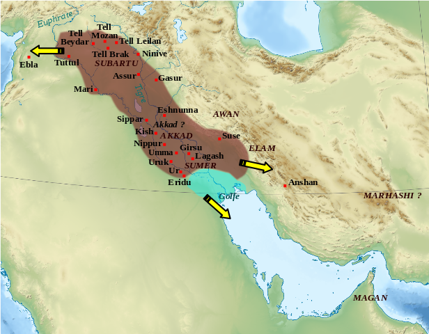
English: Map showing the approximate extension of the Akkad empire during the reign of Narâm-Sîn (2254-2218 B.C. in the short chronology).
Français: Carte de l'extension approximative de l'empire d'Akkad sous le règne de Narâm-Sîn (2254-2218 av. J.-C. selon la chronologie moyenne), et des directions des campagnes militaires extérieures.
|
| Date |
2010-11-04 22:29 (UTC) |
| Source |
|
| Author |
- derivative work: Zunkir ( talk)
|
|
Camera location
|
32° 0′ 0.00″ N, 47° 0′ 0.00″ E
|
View this and other nearby images on: Google Maps - Google Earth - OpenStreetMap |
( Info)32;47 |
 |
This is a retouched picture, which means that it has been digitally altered from its original version. Modifications: Ajout des villes, du contour approximatif de l'empire.. The original can be viewed here: Middle_East_topographic_map-blank.svg. Modifications made by Zunkir.
|
Licensing
I, the copyright holder of this work, hereby publish it under the following licenses:
 |
Permission is granted to copy, distribute and/or modify this document under the terms of the GNU Free Documentation License, Version 1.2 or any later version published by the Free Software Foundation; with no Invariant Sections, no Front-Cover Texts, and no Back-Cover Texts. A copy of the license is included in the section entitled GNU Free Documentation License. http://www.gnu.org/copyleft/fdl.htmlGFDLGNU Free Documentation Licensetruetrue
|
You may select the license of your choice.
|
File usage
The following pages on Schools Wikipedia link to this image (list may be incomplete):
This file contains additional information, probably added from the digital camera or scanner used to create or digitize it. If the file has been modified from its original state, some details may not fully reflect the modified file.
Wikipedia for Schools brings Wikipedia into the classroom. More than 2 million people benefit from the global charity work of SOS Children's Villages, and our work in 133 countries around the world is vital to ensuring a better future for vulnerable children. We have helped children in Africa for many years - you can help too...


