 |
This is a file from the Wikimedia Commons. Information from its description page there is shown below.
Commons is a freely licensed media file repository. You can help.
|
 |
File:India-map-en.svg is a vector version of this file.
It should be used in place of this raster image when superior.
File:India-map-en.png  File:India-map-en.svg
For more information about vector graphics, read about Commons transition to SVG.
There is also information about MediaWiki's support of SVG images.
|
|
Summary
| Description |
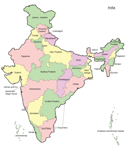
മലയാളം: ഇന്ത്യയുടെ ഭൂപടം - സംസ്ഥാനങ്ങളും കേന്ദ്രഭരണപ്രദേശങ്ങളും അടയാളപ്പെടുത്തിയിരിക്കുന്നു - ഇംഗ്ലീഷ്, പിഎൻ.ജി ഫോർമാറ്റ്
|
| Date |
10 April 2011 |
| Source |
Transferred from ml.wikipedia by Sreejith K ( talk) |
| Author |
Original uploaded by Rajeshodayanchal. |
Licensing
 |
This media file is uploaded with Malayalam loves Wikimedia event.
English | हिन्दी | italiano | македонски | മലയാളം | Deutsch | Nederlands | +/−
|
|
Rajeshodayanchal at ml.wikipedia, the copyright holder of this work, hereby publishes it under the following license:
|
Wikipedia for Schools was collected by SOS Children. SOS Childrens Villages believes that a decent childhood is essential to a happy, healthy. Our community work brings families new opportunities through education, healthcare and all manner of support. Have you heard about child sponsorship? Visit our web site to find out.


