File:Trebinje River.jpg

| |
This is a file from the Wikimedia Commons. Information from its description page there is shown below.
Commons is a freely licensed media file repository. You can help. |
|
 |
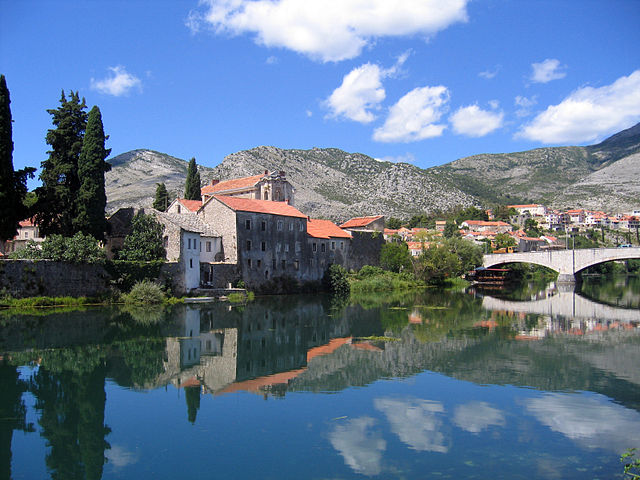
This image was selected as picture of the day on Wikimedia Commons for 24 October 2008. It was captioned as follows: English: Trebinje, a beautiful little town in Herzegovina, south-east Europe, settled on Trebisnjica (lost river).
Other languages:
Bosanski: Trebinje, predivan mali gradić u Hercegovini, na jugoistoku Evrope, smiješten na rijeci Trebišnjica (ponornica).
Česky: Trebinje – město na jihovýchodě Bosny a Hercegoviny, na ponorné říčce Trebišnjica
Dansk: Trebinje, en lille by i Bosnien-Herzegovina, ved bredden af den forsvundne flod Trebisnica.
Deutsch: Trebinje, eine Stadt im südlichen Teil von Bosnien und Herzegowina in der Nähe der Grenze zu Montenegro und Kroatien.
English: Trebinje, a beautiful little town in Herzegovina, south-east Europe, settled on Trebisnjica (lost river).
Español: Trebinje, ciudad al sur de Bosnia y Herzegovina.
Français : Trebinje, une jolie ville de Bosnie-Herzégovine (Europe du sud-est), sur les bords de la Trebisnjica, une rivière qui disparait dans une perte karstique.
Magyar: Egy festői kisváros, a Trebišnjica folyó partján fekvő Trebinje látképe Bosznia-Hercegovina déli peremén
Íslenska: Bærinn Trebinje við ána Trebisnjica í Hersegóvínu.
Italiano: Vista del paese di Trebinje nel sud della Repubblica Srpska, Bosnia-Erzegovina.
日本語: トレビニェ --トレビニェは酸化焼成を経た 酸化鉄(III)の ベンガラ色の赤瓦が 地中海地方共通の風景を作る美しい小さな町で、ヨーロッパ南東に位置する BiHの首都 サラエボから約100km南にある トレビニェ地方の主都である。町の中を流れるトレビスニカ川(Trebišnjica River)は隣国の モンテネグロと クロアチアの 石灰岩質の台地を経由し、総延長187kmのうち98kmで地表に姿を見せ、残りは地下深くを流れる世界最長の 伏流水の一つである。
Nederlands: Trebinje, de zuidelijkste stad van de Servische Republiek, in het zuiden van de regio Bosnië en Herzegovina, nabij de grens met Montenegro en Kroatië.
Polski: Miasto Trebinje w Bośni i Hercegowinie położone nad rzeką Trebisnjica.
Português: Trebinje, cidade no sul da Bósnia e Herzegovina perto da fronteira com Montenegro e Croácia.
Русский: Требинье, небольшой городок в Герцеговине, расположенный на реке Требишница.
Српски / srpski: Trebinje, predivan mali gradić u Hercegovini, na jugoistoku Evrope, smešten na reci Trebišnjica (ponornica).
Svenska: Staden Trebinje vid floden Trebišnjica i Hercegovina.
Українська: Вид на невелике герцеговинське містечко Требінє (Trebinje).
中文(简体): 波斯尼亚和黑塞哥维那小镇 特雷比涅
中文(繁體): 波士尼亞-赫塞哥維納小鎮 特雷比涅
|
Summary
| Description |
English: Trebinje, a little town in Herzegovina, south-east Europe, situated on the banks of the Trebisnjica (lost river).
|
| Date | 8 August 2005 |
| Source | Own work |
| Author | Goran Andjelic ( Hrast) |
|
Camera location |
42° 42′ 30.96″ N, 18° 20′ 56.91″ E |
This and other images at their locations on: Google Maps - Google Earth - OpenStreetMap | ( Info)42.7086;18.349141666667 |
|---|
Licensing
 |
Permission is granted to copy, distribute and/or modify this document under the terms of the GNU Free Documentation License, Version 1.2 or any later version published by the Free Software Foundation; with no Invariant Sections, no Front-Cover Texts, and no Back-Cover Texts. A copy of the license is included in the section entitled GNU Free Documentation License. http://www.gnu.org/copyleft/fdl.htmlGFDLGNU Free Documentation Licensetruetrue |
| This file is licensed under the Creative Commons Attribution-Share Alike 3.0 Unported license. | ||
|
||
| This licensing tag was added to this file as part of the GFDL licensing update.http://creativecommons.org/licenses/by-sa/3.0/CC-BY-SA-3.0Creative Commons Attribution-Share Alike 3.0 truetrue |
File usage
Metadata
| Camera manufacturer | Canon |
|---|---|
| Camera model | Canon PowerShot S50 |
| Exposure time | 1/1,000 sec (0.001) |
| F-number | f/3.2 |
| Date and time of data generation | 12:58, 8 August 2005 |
| Lens focal length | 7.09375 mm |
| Orientation | Normal |
| Horizontal resolution | 180 dpi |
| Vertical resolution | 180 dpi |
| Software used | Adobe Photoshop CS2 Windows |
| File change date and time | 12:14, 10 June 2007 |
| Y and C positioning | Centered |
| Exif version | 2.2 |
| Date and time of digitizing | 12:58, 8 August 2005 |
| Meaning of each component |
|
| Image compression mode | 5 |
| Shutter speed | 9.96875 |
| APEX aperture | 3.34375 |
| Exposure bias | 0 |
| Maximum land aperture | 2.96875 APEX (f/2.8) |
| Metering mode | Pattern |
| Flash | Flash did not fire, auto mode |
| Supported Flashpix version | 0,100 |
| Colour space | sRGB |
| Focal plane X resolution | 5,653.7102473498 |
| Focal plane Y resolution | 5,660.3773584906 |
| Focal plane resolution unit | inches |
| Sensing method | One-chip colour area sensor |
| File source | Digital still camera |
| Custom image processing | Normal process |
| Exposure mode | Auto exposure |
| White balance | Auto white balance |
| Digital zoom ratio | 1 |
| Scene capture type | Portrait |
| Supported Flashpix version | 1 |
| Image height | 1,600 px |
| Image width | 1,200 px |
| Date metadata was last modified | 14:14, 10 June 2007 |
More information
SOS Children has brought Wikipedia to the classroom. SOS Childrens Villages is an international children's charity, providing a good home and loving family to thousands of children who have lost their parents. We also work with communities to help vulnerable families stay together and raise children in the best possible environment. There are many ways to help with SOS Children's Villages.
