
File:British colonies 1763-76 shepherd1923.PNG
Size of this preview: 640 × 392 pixels.
| |
This is a file from the Wikimedia Commons. Information from its description page there is shown below.
Commons is a freely licensed media file repository. You can help. |
| Description |
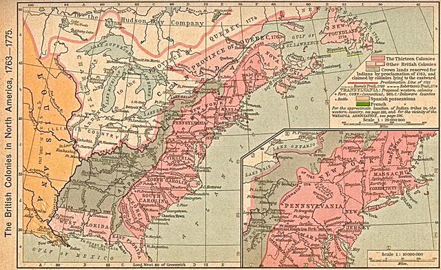
English: Map of the British colonies in North America, 1763 to 1775. This was first published in: Shepherd, William Robert (1911) " The British Colonies in North America, 1763–1765" in Historical Atlas, New York, United States: Henry Holt and Company, pp. p. 194 Retrieved on 27 October 2010.
|
|||||||||||||||||||
| Date | circa 1911 (depicting 1763-75 period) | |||||||||||||||||||
| Source | Scan from Historical Atlas by William R. Shepherd, New York, Henry Holt and Company, 1923; the map is unchanged from the 1911 original version. Original image at the Perry-Castañeda Library Map Collection at the University of Texas at Austin. |
|||||||||||||||||||
| Author |
|
|||||||||||||||||||
| Permission ( Reusing this file) |
|
|||||||||||||||||||

File usage
The following pages on Schools Wikipedia link to this image (list may be incomplete):
Metadata
Did you know...?
Wikipedia for Schools was collected by SOS Childrens Villages. SOS Children's Villages helps more than 2 million people across 133 countries around the world. Sponsoring a child is a great way to help children who need your support.