
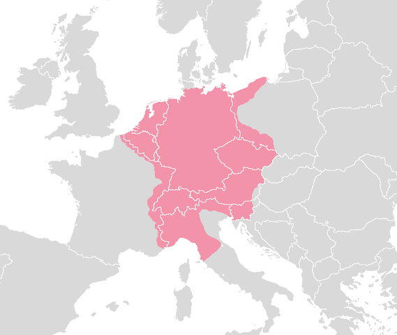
File:Holyromanempire.png
| |
This is a file from the Wikimedia Commons. Information from its description page there is shown below.
Commons is a freely licensed media file repository. You can help. |
 |
File:Holy Roman Empire ca.1600.svg is a vector version of this file. It should be used in place of this raster image when superior. File:Holyromanempire.png
For more information about vector graphics, read about Commons transition to SVG.
|
 |
Summary
DEUTSCH
Das Heilige Römische Reich Deutscher Nation um 1630
Gebiet, das vom Heiligen Römischen Reich um 1630 kontrolliert wurde mit den Grenzen der modernen Staaten.
Erstellt von; Blank map europe.png.
ENGLISH
The Holy Roman Empire around 1630.
Area controlled by the Holy Roman Empire around 1630 with the visable outlines of modern countries.
Made from; Blank map europe.png.
NEDERLANDS/DUTCH:
Het Heilige Roomse Rijk omstreeks 1630.
Gebied bestuurd door het Heilige Roomse Rijk omstreeks 1630 met de zichtbare grenzen van hedendaagse landen.
Gemaakt van; Blank map europe.png.
Made By:
Rex 16:31, 11 August 2006 (UTC)
Licensing
 |
I, the copyright holder of this work, release this work into the public domain. This applies worldwide. In some countries this may not be legally possible; if so: I grant anyone the right to use this work for any purpose, without any conditions, unless such conditions are required by law.
|
File usage
More information
Wikipedia for Schools is one of SOS Childrens Villages' many educational projects. SOS Childrens Villages is there for the children in our care until they are ready for independence. Why not try to find out more about sponsoring a child?