
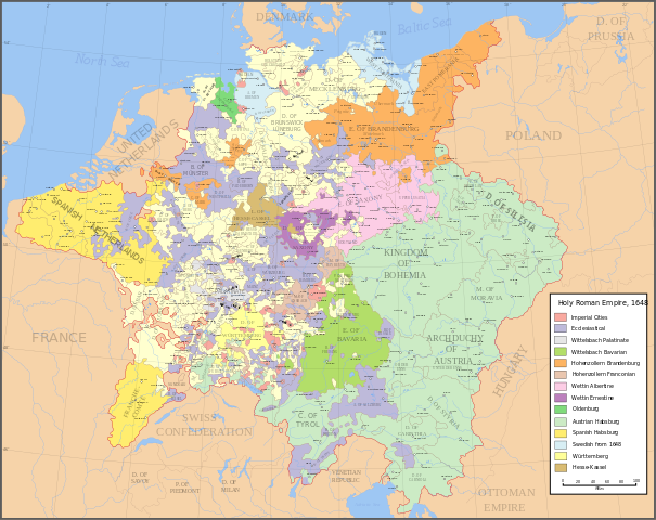
File:Holy Roman Empire 1648.svg
| |
This is a file from the Wikimedia Commons. Information from its description page there is shown below.
Commons is a freely licensed media file repository. You can help. |
Summary
| Letter | English name | German name |
|---|---|---|
| A | Archbishopric | Erzbistum |
| B | Bishopric | Bistum |
| C | County | Grafschaft |
| D | Duchy | Herzogtum |
| E | Electorate | Kurfürstentum |
| L | Landgraviate | Landgrafschaft |
| M | Margraviate | Markgrafschaft |
| P | Principality | Fürstentum |
| Description | Map of the Holy Roman Empire in 1648, after the Peace of Westphalia which ended the Thirty Years' War. Imperial cities
Ecclesiastical lands
Wittelsbach Palatinate
Wittelsbach Bavarian
Hohenzollern Brandenburg
Hohenzollern Franconia
Wettin Albertine
Wettin Ernestine
Oldenburg
Austrian Habsburg
Spanish Habsburg
Swedish after 1648
Württemberg
Hesse-Kassel Made in Inkscape. Each of the parts to the map are saved on a separate layer, so that they can be edited/moved/hidden separately when it is opened in Inkscape. All the regions such as imperial cities, ecclesiastical lands, etc. are grouped together so that the colours can be changed easily if necessary. Uses the colour scheme of WikiProject Maps and the free to use Colour Brewer. |
||||||||
| Date | 29 January 2007 | ||||||||
| Source | Made from the public domain map "Central Europe about 1648" from the Historical Atlas by William R. Shepherd, at the Perry-Castañeda Library Map Collection at the University of Texas. Further information from Overy, Richard, 2006, The Times Complete history of the world Times Books ISBN 0007181299, and from this map See also other maps at external links:
|
||||||||
| Author | Astrokey44 | ||||||||
| Permission ( Reusing this file) |
|

| |
This SVG file uses embedded text that can be easily translated into your language using this automated tool. Learn more. You can also download it and translate it manually using a text editor. العربية | беларуская (тарашкевіца) | bosanski | català | česky | dansk | Deutsch | Ελληνικά | English | Esperanto | español | eesti | فارسی | suomi | français | galego | עברית | hrvatski | magyar | Հայերեն | italiano | 日本語 | ქართული | ភាសាខ្មែរ | 한국어 | lietuvių | македонски | മലയാളം | Bahasa Melayu | Plattdüütsch | Nederlands | norsk nynorsk | norsk bokmål | polski | português | русский | slovenščina | shqip | српски / srpski | svenska | ไทย | Türkçe | татарча/tatarça | українська | Tiếng Việt | Volapük | 中文 | 中文(简体) | +/- |
File usage
Metadata
Background information
All five editions of Schools Wikipedia were compiled by SOS Children's Villages. Thanks to SOS Childrens Villages, 62,000 children are enjoying a happy childhood, with a healthy, prosperous future ahead of them. Would you like to sponsor a child?