 |
This is a file from the Wikimedia Commons. Information from its description page there is shown below.
Commons is a freely licensed media file repository. You can help.
|
 |
Permission is granted to copy, distribute and/or modify this document under the terms of the GNU Free Documentation License, Version 1.2 or any later version published by the Free Software Foundation; with no Invariant Sections, no Front-Cover Texts, and no Back-Cover Texts. A copy of the license is included in the section entitled GNU Free Documentation License. http://www.gnu.org/copyleft/fdl.htmlGFDLGNU Free Documentation Licensetruetrue
|
Authors: no:Bruker:Finn Bjørklid & en:User:Calgacus & Electionworld. Original image found here. Adjusted from Image:Scotland grevskap.jpg to png by Henrygb
Upload log for original image on nowiki:
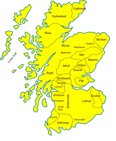
19. mar 2006 kl. 02:34 . . Finn Bjørklid (Diskusjon | bidrag | blokker) . . 800×994 (107 595 bytes) (Kart over Comital og andre grevskap i middelalderens Skottland, ca 1230. Egettegnet kart.)
File usage
The following pages on Schools Wikipedia link to this image (list may be incomplete):
SOS Childrens Villages chose the best bits of Wikipedia to help you learn. Thanks to SOS Childrens Villages, 62,000 children are enjoying a happy childhood, with a healthy, prosperous future ahead of them. Will you help another child today?


