File:Deutsches Reich1.png

Size of this preview: 520 × 480 pixels.
| |
This is a file from the Wikimedia Commons. Information from its description page there is shown below.
Commons is a freely licensed media file repository. You can help. |
Summary
| Description |
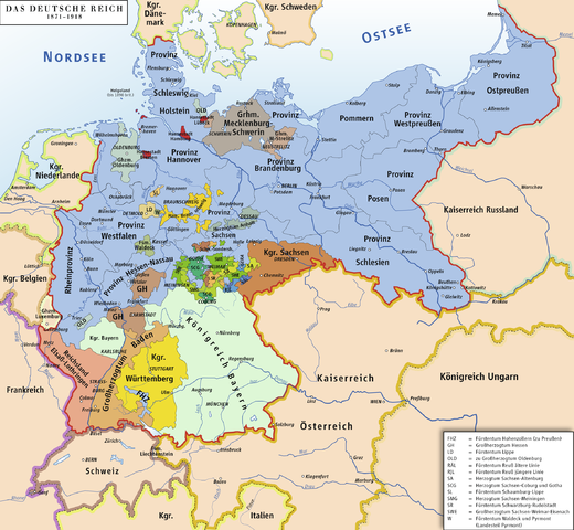
English: Map of German Reich 1871–1918
Deutsch: Karte des Deutschen Reiches 1871–1918
|
| Date | 21 September 2006 |
| Source | Own work/Source of Information: Putzger – Historischer Weltatlas, 89. Auflage, 1965; Westermanns Großer Atlas zur Weltgeschichte, 1969; Haacks geographischer Atlas. VEB Hermann Haack Geographisch-Kartographische Anstalt, Gotha/Leipzig, 1. Auflage, 1979; dtv-Atlas zur Weltgeschichte Band 1: Von den Anfängen bis zur Französischen Revolution; 23. Aufl. 1989, ISBN 3-423-03002-X |
| Author | ziegelbrenner |
| Permission ( Reusing this file) |
GNU FDL |
Licensing
|
 |
File:Deutsches Reich1.svg is a vector version of this file. It should be used in place of this raster image when superior. File:Deutsches Reich1.png
For more information about vector graphics, read about Commons transition to SVG.
|
 |
File usage
The following pages on Schools Wikipedia link to this image (list may be incomplete):
Metadata
This file contains additional information, probably added from the digital camera or scanner used to create or digitize it. If the file has been modified from its original state, some details may not fully reflect the modified file.
| Horizontal resolution | 118.11 dpc |
|---|---|
| Vertical resolution | 118.11 dpc |
I want to learn more...
You can learn about nearly 6,000 different topics on Schools Wikipedia. Thanks to SOS Children, 62,000 children are enjoying a happy childhood, with a healthy, prosperous future ahead of them. If you'd like to help, why not learn how to sponsor a child?

