
File:Is-wb-gs-gh v3.png
| |
This is a file from the Wikimedia Commons. Information from its description page there is shown below.
Commons is a freely licensed media file repository. You can help. |
| Description |
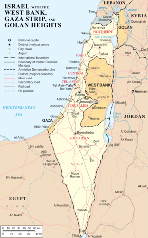
Map of Israel, the Palestinian territories (West Bank and Gaza Strip), the Golan Heights, and portions of neighbouring countries. Also United Nations deployment areas in countries adjoining Israel or Israeli-held territory, as of January 2004. |
| Date | 3 April 2007 (original upload date) (Original text : 3 April 2007) |
| Source | Originally from en.wikipedia; description page is/was here. (Original text : http://www.un.org/Depts/Cartographic/map/profile/israel.pdf (heavily modified)) |
| Author | =Original uploader was ChrisO at en.wikipedia (Original text : en:User:ChrisO) |
| Permission ( Reusing this file) |
Released into the public domain (by the author). |
Licensing
 |
This work has been released into the public domain by its author, ChrisO at the wikipedia project. This applies worldwide. In case this is not legally possible: |
|
This image is a map derived from products of the United Nations Cartographic Section. Modified versions of UNCS maps may be used provided that the UN name and reference number does not appear on any modified version and a link to the original map is provided. Modified UN maps are to be considered in the public domain. This applies worldwide. The UN maps is an open source material. You can use them to make your own maps. You do not need our permission for that. Please be advised that the UN name and reference number should not appear on any modified map. The UN map is a UN document and cannot be modified. You can say something like "Based on UN map number..." -- Vladimir Bessarabov (UNCS Cartographer), 13 April 05 |
 |
File usage
Metadata
The best way to learn
SOS Childrens Villages chose the best bits of Wikipedia to help you learn. More than 2 million people benefit from the global charity work of SOS Children, and our work in 133 countries around the world is vital to ensuring a better future for vulnerable children. Help another child by taking out a sponsorship.