
File:Germany and Poland borders during the 20th century Wlegend.png
Size of this preview: 337 × 479 pixels.
| |
This is a file from the Wikimedia Commons. Information from its description page there is shown below.
Commons is a freely licensed media file repository. You can help. |
Summary
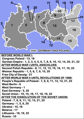
| Description | English: Anachronical map pf Germany and Poland border changes during the 20th century.
|
| Date | 6 April 2009 (original upload date) |
| Source | The map uses the map and descriptions of en::File:Germany and Poland borders during the 20th century.gif created by User:MaGioZal, but adds a legend from the text contained in the description of that file. |
| Author | see source above and original upload log below |
Licensing
 |
Permission is granted to copy, distribute and/or modify this document under the terms of the GNU Free Documentation License, Version 1.2 or any later version published by the Free Software Foundation; with no Invariant Sections, no Front-Cover Texts, and no Back-Cover Texts. A copy of the license is included in the section entitled GNU Free Documentation License.
|
| This file is licensed under the Creative Commons Attribution-Share Alike 3.0 Unported license. | ||
|
||
| This licensing tag was added to this file as part of the GFDL licensing update.
|
File usage
The following pages on Schools Wikipedia link to this image (list may be incomplete):
Metadata
About Schools Wikipedia
SOS Children chose the best bits of Wikipedia to help you learn. In 133 nations around the world, SOS Childrens Villages works to bring better education and healthcare to families in desperate need of support. Why not try to learn more about child sponsorship?