
File:Peru Quake Aug 15-2007.jpg
Size of this preview: 407 × 479 pixels.
| |
This is a file from the Wikimedia Commons. Information from its description page there is shown below.
Commons is a freely licensed media file repository. You can help. |
Summary
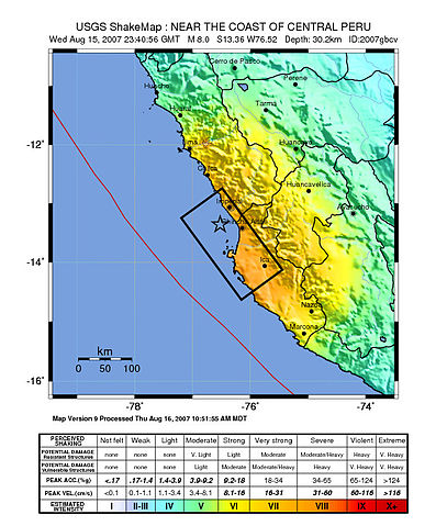
Image: Shake map of the magnitude 8.0 earthquake in Peru on August 15, 2007. Epicenter marked at star. Black box, placed by USGS, marks areas of Peru to be hardest hit.
Source: http://earthquake.usgs.gov/eqcenter/shakemap/global/shake/2007gbcv/
Licensing
 |
This image is in the public domain because it contains materials that originally came from the United States Geological Survey, an agency of the United States Department of the Interior. For more information, see the official USGS copyright policy. български | català | Deutsch | English | español | eesti | suomi | français | galego | italiano | 한국어 | македонски | മലയാളം | Nederlands | polski | português | русский | Türkçe | 中文 | 中文(简体) | +/− |
|
derivative works
Derivative works of this file:
File usage
The following pages on Schools Wikipedia link to this image (list may be incomplete):
Learn more
Wikipedia for Schools is one of SOS Childrens Villages' many educational projects. SOS Children helps more than 2 million people across 133 countries around the world. Have you thought about sponsoring a child?