
File:Shackleton Endurance Aurora map2.png
Size of this preview: 390 × 479 pixels.
| |
This is a file from the Wikimedia Commons. Information from its description page there is shown below.
Commons is a freely licensed media file repository. You can help. |
Summary
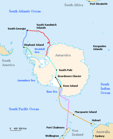
| Description | Map of the routes of the ships Endurance and Aurora, the support team route, and the planned trans-Antarctic route of the British Imperial Trans-Antarctic Expedition led by Ernest Shackleton in 1914–15. Voyage of Endurance
Drift of Endurance in pack ice
Sea-ice drift after Endurance sinks
Voyage of the lifeboat James Caird
Planned trans-Antarctic route
Voyage of Aurora to Antarctica
Retreat of Aurora
Supply depot route
|
| Date | 13 January 2008 |
| Source | Based on Image:ShackletonEnduranceBlank.png, which is a modification by User:Like tears in rain of Image:Antarctica Map.png, a U.S. government work in the public domain, further modified by User:Finetooth |
| Author | Finetooth, Like tears in rain, U.S Central Intelligence Agency |
Licensing
|

and
 |
This image is in the public domain because it contains materials that originally came from the United States Central Intelligence Agency's World Factbook.
|
 |
 |
This map image could be recreated using vector graphics as an SVG file. This has several advantages; see Commons:Media for cleanup for more information. If an SVG form of this image is already available, please upload it. After uploading an SVG, replace this template with {{ vector version available|new image name.svg}}. |
File usage
The following pages on Schools Wikipedia link to this image (list may be incomplete):
Schools Wikipedia and SOS Children
All five editions of Schools Wikipedia were compiled by SOS Childrens Villages. The world's largest orphan charity, SOS Children's Villages brings a better life to more than 2 million people in 133 countries around the globe. There are many ways to help with SOS Children's Villages.