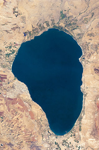
File:Lake Tiberias (Sea of Galilee), Northern Israel.jpg

Size of this preview: 318 × 479 pixels.
| |
This is a file from the Wikimedia Commons. Information from its description page there is shown below.
Commons is a freely licensed media file repository. You can help. |
Summary
| Description |
English: Israel’s largest freshwater lake, Lake Tiberias, is also known as the Sea of Tiberias, Lake of Gennesaret, Lake Kinneret, and the Sea of Galilee. The lake measures just more than 21 kilometres north-south, and it is only 43 meters deep. The lake is fed partly by underground springs related to the Jordan sector of the Great Rift Valley, but most of its water comes from the Jordan River, which enters from the north. The river’s winding course can be seen draining the south end of the lake at image bottom. Angular green and brown field patterns clothe most hillsides in this arid landscape. Bright roof tops are the hallmark of several villages in the area. The largest grouping of bright roofs and city blocks indicates the location of Tiberias (named for the Roman Emperor Tiberius), visible at image left on the south-western shore of the lake.
|
||||||||||||||||||||||||||||||||||||||||||||||||||
| Date | 14 September 2009 | ||||||||||||||||||||||||||||||||||||||||||||||||||
| Source | NASA Earth Observatory | ||||||||||||||||||||||||||||||||||||||||||||||||||
| Author | This image was taken by the NASA Expedition 20 crew. | ||||||||||||||||||||||||||||||||||||||||||||||||||
Image acquired with a Nikon D2Xs digital camera fitted with an 400 mm lens, and is provided by the ISS Crew Earth Observations experiment and Image Science & Analysis Laboratory, Johnson Space Centre.
Licensing
| Public domainPublic domainfalsefalse |
 |
This file is in the public domain because it was solely created by NASA. NASA copyright policy states that "NASA material is not protected by copyright unless noted". (See Template:PD-USGov, NASA copyright policy page or JPL Image Use Policy.) |
 |
 |
Warnings:
|
File usage
The following pages on Schools Wikipedia link to this image (list may be incomplete):
Metadata
This file contains additional information, probably added from the digital camera or scanner used to create or digitize it. If the file has been modified from its original state, some details may not fully reflect the modified file.
| Camera manufacturer | NIKON CORPORATION |
|---|---|
| Camera model | NIKON D2Xs |
| Exposure time | 1/350 sec (0.0028571428571429) |
| F-number | f/9.5 |
| ISO speed rating | 200 |
| Date and time of data generation | 10:21, 15 August 2009 |
| Lens focal length | 400 mm |
| Orientation | Normal |
| Horizontal resolution | 72 dpi |
| Vertical resolution | 72 dpi |
| Software used | Adobe Photoshop CS4 Macintosh |
| File change date and time | 10:55, 10 September 2009 |
| Exposure Program | Normal program |
| Exif version | 2.21 |
| Date and time of digitizing | 10:21, 15 August 2009 |
| Shutter speed | 8.451211 |
| APEX aperture | 6.495855 |
| Exposure bias | 0 |
| Maximum land aperture | 3 APEX (f/2.83) |
| Metering mode | Pattern |
| Light source | Unknown |
| Flash | Flash did not fire |
| DateTime subseconds | 00 |
| DateTimeOriginal subseconds | 00 |
| DateTimeDigitized subseconds | 00 |
| Colour space | Uncalibrated |
| Sensing method | One-chip colour area sensor |
| Custom image processing | Normal process |
| Exposure mode | Auto exposure |
| White balance | Auto white balance |
| Digital zoom ratio | 1 |
| Focal length in 35 mm film | 600 mm |
| Scene capture type | Standard |
| Contrast | Soft |
| Saturation | Normal |
| Sharpness | Normal |
| Subject distance range | Unknown |
The best way to learn
All five editions of Schools Wikipedia were compiled by SOS Children. SOS Childrens Villages is there for the children in our care until they are ready for independence. There are many ways to help with SOS Children.
