Checked content

File:AYool topography 15min.png

Summary

Description
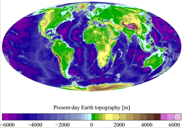
English: Present-day Earth topography and bathymetry at 15- minute horizontal resolution. Derived from the National Geophysical Data Centre's TerrainBase Digital Terrain Model (v1.0). The original dataset is at 5-minute resolution, and this has been averaged down to 15-minute resolution. It is plotted here using a Mollweide projection (using MATLAB and the M_Map package).
Date 7 March 2007
Source English Wikipedia
Author Plumbago

Licensing

I, the copyright holder of this work, hereby publish it under the following licenses:
GNU head Permission is granted to copy, distribute and/or modify this document under the terms of the GNU Free Documentation License, Version 1.2 or any later version published by the Free Software Foundation; with no Invariant Sections, no Front-Cover Texts, and no Back-Cover Texts. A copy of the license is included in the section entitled GNU Free Documentation License.

w:en:Creative Commons
attribution share alike
This file is licensed under the Creative Commons Attribution-Share Alike 3.0 Unported license.
You are free:
  • to share – to copy, distribute and transmit the work
  • to remix – to adapt the work
Under the following conditions:
  • attribution – You must attribute the work in the manner specified by the author or licensor (but not in any way that suggests that they endorse you or your use of the work).
  • share alike – If you alter, transform, or build upon this work, you may distribute the resulting work only under the same or similar license to this one.
This licensing tag was added to this file as part of the GFDL licensing update.

w:en:Creative Commons
attribution
This file is licensed under the Creative Commons Attribution 2.5 Generic license.
You are free:
  • to share – to copy, distribute and transmit the work
  • to remix – to adapt the work
Under the following conditions:
  • attribution – You must attribute the work in the manner specified by the author or licensor (but not in any way that suggests that they endorse you or your use of the work).

You may select the license of your choice.
The following pages on Schools Wikipedia link to this image (list may be incomplete):

Metadata

What is Schools Wikipedia?

Wikipedia for Schools brings Wikipedia into the classroom. By supporting vulnerable children right through to adulthood, SOS Childrens Villages makes a lasting difference to the lives of thousands of people. Education is a key part of our work, and our schools provide high-quality teaching to the children in our care. There are many ways to help with SOS Childrens Villages.