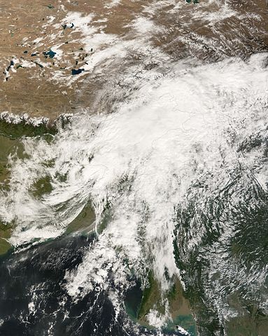
File:Sidr 16 nov 2007 0605Z.jpg
- File
- File usage
- Wikipedia for Schools...

| |
This is a file from the Wikimedia Commons. Information from its description page there is shown below.
Commons is a freely licensed media file repository. You can help. |
|
Warning |
Some browsers may have trouble displaying this image at full resolution: This image has a large number of pixels and may either not load properly or cause your browser to freeze. | Interactive large-image-viewer ( non-Flash) |
|---|
Summary
| Description | Tropical Cyclone Sidr had been moving slowly north and gathering power as it drew closer to the coastline around the Mouth of the Ganges. However, in the hours before landfall, according to the Joint Typhoon Warning Centre, the powerful Category 4 cyclone lost strength and picked up its speed. As of November 16, peak winds had fallen to 110 kilometers per hour (70 miles per hour) and the storm was moving inland at 50 km/hr (30 mph). The Moderate Resolution Imaging Spectroradiometer (MODIS) on NASA’s Terra satellite acquired this photo-like image at 11:35 a.m. local time (6:05 UTC) on November 16, 2007. The storm appears to have no particular organization, dramatically different from just one day earlier, when it was an unmistakably powerful cyclone. As of November 16, sources such as the International Herald Tribune were reporting casualties from Sidr of perhaps 200 people in Bangladesh. India was largely spared from the storm. Evacuations had removed hundreds of thousands of people in both countries ahead of the storm. The storm surge and rain did flood many areas, overwhelming some protective dikes, burying fields under water, and washing away many mud homes in the coastal area. Power lines were toppled in many areas, and all of Bangladesh was without power for several hours during the height of the storm. Western Bangladesh, where the storm made landfall, is the most heavily populated low-lying area in the world, with a history of severe causalities from previous storms due to both direct flooding and storm surge. In 1970, a Category 3 storm that made landfall in the same vicinity caused 300,000 deaths and was one of the most deadly natural disasters in modern history. Another 138,000 people perished in 1991 from a similar cyclone. |
||||||
| Date | 16 November 2007 | ||||||
| Source | http://earthobservatory.nasa.gov/NaturalHazards/natural_hazards_v2.php3?img_id=14630 | ||||||
| Author | NASA image created by Jesse Allen, using data provided by the MODIS Rapid Response team. | ||||||
| Permission ( Reusing this file) |
|
Wikipedia for Schools...
Wikipedia for Schools is designed to make learning fun and easy. SOS Children's Villages is an international children's charity, providing a good home and loving family to thousands of children who have lost their parents. We also work with communities to help vulnerable families stay together and raise children in the best possible environment. We have helped children in Africa for many years - you can help too...


