 |
This is a file from the Wikimedia Commons. Information from its description page there is shown below.
Commons is a freely licensed media file repository. You can help.
|
Summary
| Description |
Afrikaans: Die veranderende strekking van die Frankiese Ryk van 481 tot 814.
Alemannisch: S Frankeriich vo 481 bis 814.
Català: Mapa de l'expansió de l'Imperi Franc, de 481 to 814.
Deutsch: Karte der Ausdehnung des Fränkischen Reichs 481 bis 814.
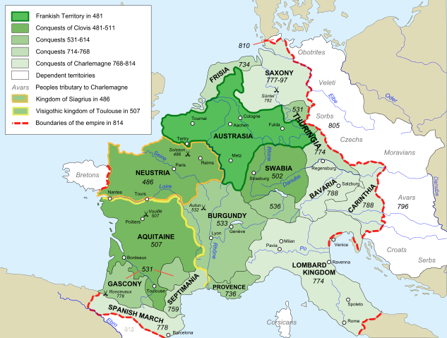
English: Map of the rise of Frankish Empire, from 481 to 814.
Español: Mapa de la expansión del Imperio Franco, entre 481 y 814.
Euskara: Frankoen Inperioaren hedapenaren mapa, 481-814 urteen bitartean.
Français: Carte de l'expansion de l'empire Franc, entre 481 et 814.
Italiano: Carta dell'espansione dell'impero dei Franchi tra il 481 e il 814.
Polski: Mapa rozwoju Imperium Franków w latach 481-814
Português: Mapa da expansão do Império Franco, entre 481 e 814.
Македонски: Карта на подемот на Франкското царство, од 481 до 814 г.
Русский: Карта расширения империи франков, между 481 и 814.
|
| Date |
15 October 2007 |
| Source |
Own work, from Image:Frankish empire.jpg, itself from File:Growth of Frankish Power, 481-814.jpg, from the Historical Atlas by William R. Shepherd (Shepherd, William. Historical Atlas. New York: Henry Holt and Company, 1911.) |
| Author |
Sémhur |
|
Camera location
|
48° 0′ 0.00″ N, 5° 0′ 0.00″ E
|
This and other images at their locations on: Google Maps - Google Earth - OpenStreetMap |
( Info)48;5 |
This map was improved or created by the Wikigraphists of the Graphic Lab (fr). You can propose images to clean up, improve, create or translate as well.
বাংলা | català | česky | Deutsch | Deutsch (Sie-Form) | Ελληνικά | English | Esperanto | español | suomi | français | עברית | magyar | Հայերեն | italiano | 한국어 | македонски | Bahasa Melayu | Plattdüütsch | Nederlands | occitan | polski | português | română | русский | slovenščina | svenska | татарча/tatarça | Türkçe | українська | 中文 | 中文(简体) | 中文(繁體) | Zazaki | +/−
 |
This SVG file uses embedded text that can be easily translated into your language using this automated tool. Learn more. You can also download it and translate it manually using a text editor.
العربية | беларуская (тарашкевіца) | bosanski | català | česky | dansk | Deutsch | Ελληνικά | English | Esperanto | español | eesti | فارسی | suomi | français | galego | עברית | hrvatski | magyar | Հայերեն | italiano | 日本語 | ქართული | ភាសាខ្មែរ | 한국어 | lietuvių | македонски | മലയാളം | Bahasa Melayu | Plattdüütsch | Nederlands | norsk nynorsk | norsk bokmål | polski | português | русский | slovenščina | shqip | српски / srpski | svenska | ไทย | Türkçe | татарча/tatarça | українська | Tiếng Việt | Volapük | 中文 | 中文(简体) | +/-
|
|
|
This vector image was created with Inkscape. |
Licensing
I, the copyright holder of this work, hereby publish it under the following licenses:
 |
Copyleft: This work of art is free; you can redistribute it and/or modify it according to terms of the Free Art License. You will find a specimen of this license on the Copyleft Attitude site as well as on other sites. http://artlibre.org/licence/lal/enFALFree Art Licensefalsetrue |
You may select the license of your choice.
|
File usage
The following pages on Schools Wikipedia link to this image (list may be incomplete):
This file contains additional information, probably added from the digital camera or scanner used to create or digitize it. If the file has been modified from its original state, some details may not fully reflect the modified file.
Wikipedia for Schools is one of SOS Children's Villages' many educational projects. SOS Children is an international children's charity, providing a good home and loving family to thousands of children who have lost their parents. We also work with communities to help vulnerable families stay together and raise children in the best possible environment. There are many ways to help with SOS Childrens Villages.


