 |
This is a file from the Wikimedia Commons. Information from its description page there is shown below.
Commons is a freely licensed media file repository. You can help.
|
| Artist |
http://www.geographicus.com/mm5/cartographers/ogilby.txt |
| Title |
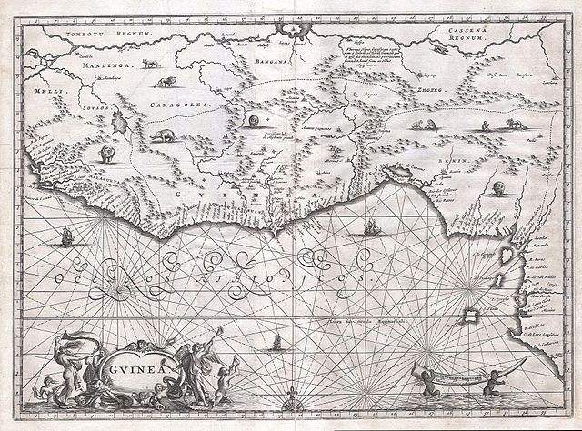
Guinea. (Gvinea.) |
| Description |
English: This is an extraordinary 1670 map of West Africa by English cartographer John Ogilby. Depicts the African Gold Coast, Ivory Coast, and Slave Coast from Guniea south through the modern nations of, Sierra Leone, Liberia, Mali, Burkina Faso, Cote D’Ivoire, Ghana, Togo, Benin, Nigeria, Cameroon, Equatorial Guinea and Gabon. Ogilby modeled this map after the 1639 Hondius / Janesson map. Here was can see the practice satirized by Jonathan Swift regarding the lack in information on the interior, they had to “place elephants for want of towns”. Indeed the interior is decorated with stylized renderings of African animals including lions, elephants, cheetahs, and apes. On the water several sailing vessels are depicted. In the lower left an elaborate decorative Cartouche labeled the region simply Guinea. On the bottom right two cherubic Africans haul a gigantic elephant tusk.
|
| Date |
1670 (undated) |
| Dimensions |
Height: 10.5 in (26.7 cm). Width: 14.5 in (36.8 cm). |
| Accession number |
Geographicus code: Guinea-ogilby-1670 |
| Source/Photographer |
 |
This file was provided to Wikimedia Commons by Geographicus Rare Antique Maps, a specialist dealer in rare maps and other cartography of the 15th, 16th, 17th, 18th and 19th centuries, as part of a cooperation project.
|
|
Permission
( Reusing this file) |
This is a faithful photographic reproduction of an original two-dimensional work of art. The work of art itself is in the public domain for the following reason:
| Public domainPublic domainfalsefalse |
 |
This image (or other media file) is in the public domain because its copyright has expired.
This applies to Australia, the European Union and those countries with a copyright term of life of the author plus 70 years.
 You must also include a United States public domain tag to indicate why this work is in the public domain in the United States. Note that a few countries have copyright terms longer than 70 years: Mexico has 100 years, Colombia has 80 years, and Guatemala and Samoa have 75 years, Russia has 74 years for some authors. This image may not be in the public domain in these countries, which moreover do not implement the rule of the shorter term. Côte d'Ivoire has a general copyright term of 99 years and Honduras has 75 years, but they do implement the rule of the shorter term. You must also include a United States public domain tag to indicate why this work is in the public domain in the United States. Note that a few countries have copyright terms longer than 70 years: Mexico has 100 years, Colombia has 80 years, and Guatemala and Samoa have 75 years, Russia has 74 years for some authors. This image may not be in the public domain in these countries, which moreover do not implement the rule of the shorter term. Côte d'Ivoire has a general copyright term of 99 years and Honduras has 75 years, but they do implement the rule of the shorter term.
|
|
This file has been identified as being free of known restrictions under copyright law, including all related and neighboring rights.
|
The official position taken by the Wikimedia Foundation is that "faithful reproductions of two-dimensional public domain works of art are public domain, and that claims to the contrary represent an assault on the very concept of a public domain". For details, see Commons:When to use the PD-Art tag.
This photographic reproduction is therefore also considered to be in the public domain. Please be aware that depending on local laws, re-use of this content may be prohibited or restricted in your jurisdiction. See Commons:Reuse of PD-Art photographs.
{{ PD-Art}} template without parameter: please specify why the underlying work is public domain in both the source country and the United States
(Usage: {{PD-Art|1=|deathyear=|country=|date=}}, where parameter #1 can be PD-old-auto, PD-old-auto-1923, PD-old-100 or similar)
|
|
File usage
The following pages on Schools Wikipedia link to this image (list may be incomplete):
Schools Wikipedia was created by children's charity SOS Children. The world's largest orphan charity, SOS Children brings a better life to more than 2 million people in 133 countries around the globe. Help another child by taking out a sponsorship.


