
File:Byzantine Constantinople eng.png
Size of this preview: 531 × 479 pixels.
| |
This is a file from the Wikimedia Commons. Information from its description page there is shown below.
Commons is a freely licensed media file repository. You can help. |
| |
This is a featured picture, which means that members of the community have identified it as one of the finest images on the English Wikipedia, adding significantly to its accompanying article. If you have a different image of similar quality, be sure to upload it using the proper free license tag, add it to a relevant article, and nominate it. |
| |
This image was selected as picture of the day on the English Wikipedia for June 29, 2009. |
|
Summary
| Description |
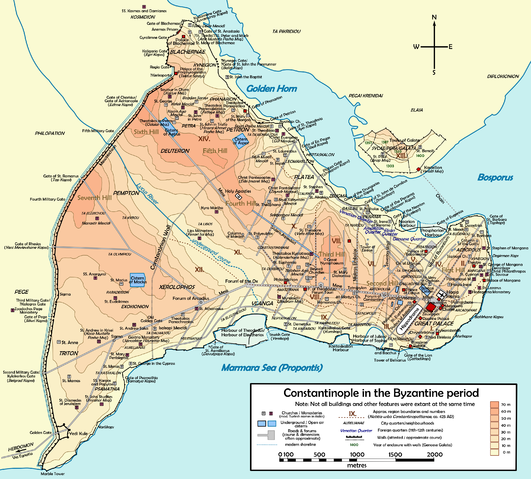
English: Topographical map of Constantinople during the Byzantine period. Main map source: R. Janin, Constantinople Byzantine. Developpement urbain et repertoire topographique. Road network and some other details based on Dumbarton Oaks Papers 54; data on many churches, especially unidentified ones, taken from the University of New York's The Byzantine Churches of Istanbul project. Other published maps and accounts of the city have been used for corroboration.
Български: Топографска карта на Константинопол (Цариград) през византийския период. Източник: R. Janin, Constantinople Byzantine. Developpement urbain et repertoire topographique. Пътната мрежа и някои други детайли се основават на Dumbarton Oaks Papers 54 и други публикувани източници.
Deutsch: Topografische Karte Konstantinopels während des byzantinischen Zeitraums. Quelle: R. Janin, Constantinople Byzantine. Developpement urbain et repertoire topographique. Straßennetz und andere Einzelheiten basiert auf Dumbarton Oaks Papers 54. Kirchen, insb. nicht identifizierte und ausgegrabene Bauten sind aus dem The Byzantine Churches of Istanbul entnommen. Andere herausgegebenen Quellen wurden behilfsmäßig gebraucht.
Ελληνικά: Τοπογραφικός χάρτης Κωνσταντινουπόλεως κατά τη Βυζαντινή περίοδο. Βασική πηγή χάρτη: R. Janin, Constantinople Byzantine. Developpement urbain et repertoire topographique. Το οδικό δίκτυο και διάφορες άλλες λεπτομέρειες με βάση το Dumbarton Oaks Papers 54. Πληροφορίες για τις εκκλησίες, ιδιαίτερα τις μη ταυτοποιημένες, από την ιστοσελίδα The Byzantine Churches of Istanbul του Πανεπιστημίου της Νέας Υόρκης. Although I've striven to make this map as complete and correct as possible, there may be some errors or omissions. Any corrections & suggestions are welcome. |
||||||||
| Date | 28 October 2008 | ||||||||
| Source | Own work | ||||||||
| Author | Cplakidas | ||||||||
| Permission ( Reusing this file) |
|

| |
Open this image as an overlay in Google Earth ( Google Maps, Bing) | ( Help| Source) |
File usage
The following pages on Schools Wikipedia link to this image (list may be incomplete):
Metadata
Find out about Schools Wikipedia
All five editions of Schools Wikipedia were compiled by SOS Children's Villages. Thanks to SOS Children's Villages, 62,000 children are enjoying a happy childhood, with a healthy, prosperous future ahead of them. Why not try to find out more about sponsoring a child?
Categories: