 |
This is a file from the Wikimedia Commons. Information from its description page there is shown below.
Commons is a freely licensed media file repository. You can help.
|
Summary
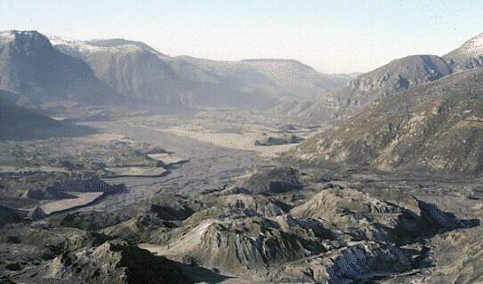
This downstream view of the North Fork Toutle River valley, north and west of St. Helens, shows part of the nearly 2/3 cubic miles (2.3 cubic kilometers) of debris avalanche that slid from the volcano on May 18. This is enough material to cover Washington, D.C. to a depth of 14 feet (4 meters). The avalanche traveled approximately 15 miles (24 kilometers) downstream at a velocity exceeding 150 miles per hour (240 kilometers/hour). It left behind a hummocky deposit with an average thickness of 150 feet (45 meters) and a maximum thickness of 600 feet (180 meters). (November 30, 1983, by Lyn Topinka, USGS/CVO) USGS image
Summary
| Description |
North Fork Toutle River valley in November 1983 |
| Date |
|
| Source |
http://vulcan.wr.usgs.gov/Volcanoes/MSH/SlideSet/ljt_slideset_old.html |
| Author |
U.S. government |
Permission
( Reusing this file) |
PD
|
Licensing
| Public domainPublic domainfalsefalse |
 |
This image is in the public domain because it contains materials that originally came from the United States Geological Survey, an agency of the United States Department of the Interior. For more information, see the official USGS copyright policy.
български | català | Deutsch | English | español | eesti | suomi | français | galego | italiano | 한국어 | македонски | മലയാളം | Nederlands | polski | português | русский | Türkçe | 中文 | 中文(简体) | +/−
|
|
 |
Textual information once visible in the image itself has been moved into the image metadata and/or image description page. This makes the image easier to reuse and more language-neutral, and makes the text easier to process and search for. Commons discourages placing visible textual information in images. All licenses accepted on Commons permit this type of modification as a derivative work. If attribution information were removed and the image is not public domain, replace this tag with {{ attribution metadata from licensed image}}.
|
File usage
The following pages on Schools Wikipedia link to this image (list may be incomplete):
This file contains additional information, probably added from the digital camera or scanner used to create or digitize it. If the file has been modified from its original state, some details may not fully reflect the modified file.
Wikipedia for Schools is one of SOS Childrens Villages' many educational projects. By supporting vulnerable children right through to adulthood, SOS Childrens Villages makes a lasting difference to the lives of thousands of people. Education is a key part of our work, and our schools provide high-quality teaching to the children in our care. Try to find out how you can help children in other countries on our web site.


