 |
This is a file from the Wikimedia Commons. Information from its description page there is shown below.
Commons is a freely licensed media file repository. You can help.
|
Summary
| DescriptionMap of Iceland.svg |
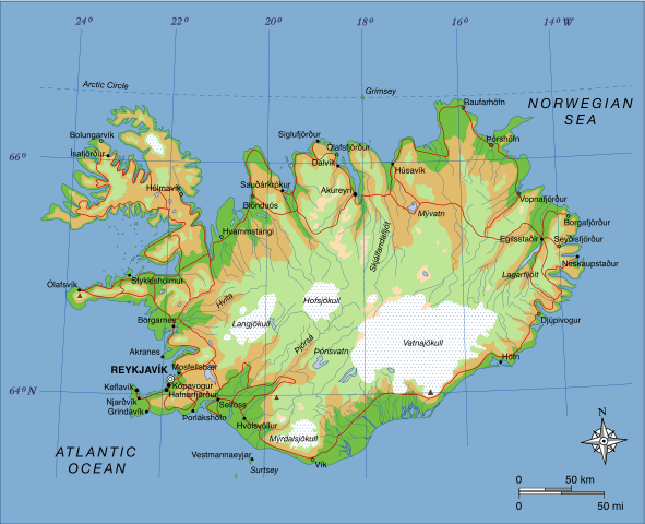
A map of Iceland, showing major towns, rivers, lakes and glaciers. Translated from a map on the Greek Wikipedia ( located here).
|
| Date |
23 June 2007 |
| Source |
Own work, based on File:Map of Iceland el.svg created by el:user:Αντιγόνη |
| Author |
Max Naylor |
Licensing
| Public domainPublic domainfalsefalse |
 |
This work has been released into the public domain by its author, I, Max Naylor. This applies worldwide.
In some countries this may not be legally possible; if so:
I, Max Naylor grants anyone the right to use this work for any purpose, without any conditions, unless such conditions are required by law.Public domainPublic domainfalsefalse
|
| Annotations |
This image is annotated: View the annotations at Commons |
|
|
File usage
The following pages on Schools Wikipedia link to this image (list may be incomplete):
This file contains additional information, probably added from the digital camera or scanner used to create or digitize it. If the file has been modified from its original state, some details may not fully reflect the modified file.
SOS Childrens Villages has brought Wikipedia to the classroom. SOS Children is an international children's charity, providing a good home and loving family to thousands of children who have lost their parents. We also work with communities to help vulnerable families stay together and raise children in the best possible environment. There are many ways to help with SOS Children's Villages.


