 |
This is a file from the Wikimedia Commons. Information from its description page there is shown below.
Commons is a freely licensed media file repository. You can help.
|
 |
File:Global spread of H5N1 map.svg is a vector version of this file.
It should be used in place of this raster image when superior.
File:Global spread of H5N1 map.PNG  File:Global spread of H5N1 map.svg
For more information about vector graphics, read about Commons transition to SVG.
There is also information about MediaWiki's support of SVG images.
|
|
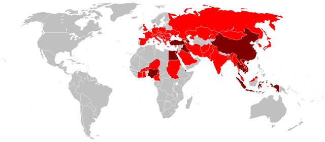
Colour codes
|
|
→ Countries with poultry or wild birds killed by H5N1 |
|
|
→ Countries with humans, poultry and wild birds killed by H5N1. |
Licensing
I, the copyright holder of this work, hereby publish it under the following licenses:
 |
Permission is granted to copy, distribute and/or modify this document under the terms of the GNU Free Documentation License, Version 1.2 or any later version published by the Free Software Foundation; with no Invariant Sections, no Front-Cover Texts, and no Back-Cover Texts. A copy of the license is included in the section entitled GNU Free Documentation License. http://www.gnu.org/copyleft/fdl.htmlGFDLGNU Free Documentation Licensetruetrue
|
You may select the license of your choice.
|
File usage
The following pages on Schools Wikipedia link to this image (list may be incomplete):
All five editions of Schools Wikipedia were compiled by SOS Children. SOS Children's Villages is there for the children in our care until they are ready for independence. Have you heard about child sponsorship? Visit our web site to find out.


