File:Continents vide couleurs.png

Size of this preview: 640 × 325 pixels.
| |
This is a file from the Wikimedia Commons. Information from its description page there is shown below.
Commons is a freely licensed media file repository. You can help. |
 |
File:Continents_vide_couleurs-automatedvector.svg is a vector version of this file. It should be used in place of this raster image when superior. File:Continents vide couleurs.png
For more information about vector graphics, read about Commons transition to SVG.
|
 |
Summary
| Description |
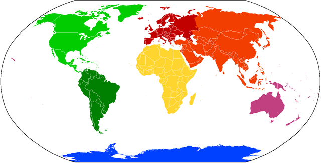
Deutsch: Karte der Kontinente, basierend auf File:BlankMap-World.png. Die Karte enthält keine Beschriftung, damit sie als Grundlage für verschiedene Sprachen benutzt werden kann. Kontinente, für die verschiedene Aufteilungen in Gebrauch sind (z.B. Amerika bzw. Nord-/Südamerika oder Eurasien bzw. Europa/Asien) sind in verschiedenen Abstufungen der selben Farbe gehalten.
Amerika: Nordamerika
Südamerika
Eurasien: Asien
Europa
Afrika
Australien/ Ozeanien
Antarktik
English: Compiled chiefly from File:BlankMap-World.png. Blank to permit labels in various languages. Controversial continents/subcontinents (i.e. one America or two, Eurasia vs Europe and Asia) are in different shades of the same colour:
America: North America not South America
Eurasia: Asia
Europe
Africa
Australia/ Oceania
Antarctica
Français: Carte des continents, depuis File:BlankMap-World.png. C'est vide pour permettre aux gens d'ajouter des étiquettes propres à diverses langues. Les continents/sous-continents dont le statut est controversé (par example une Amérique ou deux, Eurasie vs Europe et Asie) sont illustrés en teints différents de la même couleur.
Italiano: Carta dei continenti, basata su File:BlankMap-World.png. La carta non contiene descrizioni, in modo che possa essere utilizzata in ogni lingua. I continenti che sono spesso menzionati come diversi (ad esempio America e Nord/Sud Amerika) sono mostrati in diverse gradazioni dello stesso colore.
|
||||||||||||||
| Date | |||||||||||||||
| Source | File:BlankMap-World.png | ||||||||||||||
| Author | User:Cogito ergo sumo | ||||||||||||||
| Permission ( Reusing this file) |
|
File usage
The following pages on Schools Wikipedia link to this image (list may be incomplete):
Metadata
This file contains additional information, probably added from the digital camera or scanner used to create or digitize it. If the file has been modified from its original state, some details may not fully reflect the modified file.
| Horizontal resolution | 37.79 dpc |
|---|---|
| Vertical resolution | 37.79 dpc |
A background to Schools Wikipedia
SOS Children chose the best bits of Wikipedia to help you learn. The world's largest orphan charity, SOS Children's Villages brings a better life to more than 2 million people in 133 countries around the globe. Would you like to sponsor a child?

