Checked content

File:Amarnamap.png

Atlas This map has been uploaded by Electionworld from en.wikipedia.org to enable the Wikimedia-logo.svgWikimedia Atlas of the World Gnome-globe.svg. Original uploader to en.wikipedia.org was Briangotts, known as Briangotts at en.wikipedia.org. Electionworld is not the creator of this map. Licensing information is below.

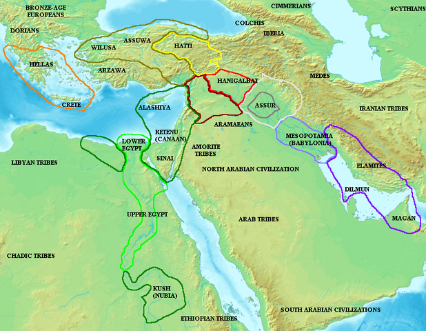
Map of the ancient Near East during the Amarna period, showing the great powers of the period: Egypt (green), Hatti (yellow), the Kassite kingdom of Babylon (purple), Assyria (grey), and Mittani (red). Lighter areas show direct control, darker areas represent spheres of influence. The extent of the Achaean/ Mycenaean civilization is shown in orange.

On the map above: the territory between Medes and Iberia was called Ararat or Armenia, around the lake Van.


Licensing

I, the copyright holder of this work, hereby publish it under the following license:
GNU head Permission is granted to copy, distribute and/or modify this document under the terms of the GNU Free Documentation License, Version 1.2 or any later version published by the Free Software Foundation; with no Invariant Sections, no Front-Cover Texts, and no Back-Cover Texts. A copy of the license is included in the section entitled GNU Free Documentation License.

w:en:Creative Commons
attribution share alike
This file is licensed under the Creative Commons Attribution-Share Alike 3.0 Unported license.
You are free:
  • to share – to copy, distribute and transmit the work
  • to remix – to adapt the work
Under the following conditions:
  • attribution – You must attribute the work in the manner specified by the author or licensor (but not in any way that suggests that they endorse you or your use of the work).
  • share alike – If you alter, transform, or build upon this work, you may distribute the resulting work only under the same or similar license to this one.
This licensing tag was added to this file as part of the GFDL licensing update.

The following pages on Schools Wikipedia link to this image (list may be incomplete):

Metadata

The best way to learn

Wikipedia for Schools is one of SOS Children's Villages' many educational projects. SOS Children's Villages is a global charity founded in 1949 to give children who have lost everything the childhood they deserve. Will you help another child today?