
File:GiantsCastlePanoramaSmall.jpg
Size of this preview: 640 × 88 pixels.
| |
This is a file from the Wikimedia Commons. Information from its description page there is shown below.
Commons is a freely licensed media file repository. You can help. |
Summary
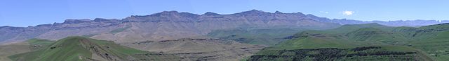
| Description | L: 29°20′07″S 29°27′19″E / 29.33528°S 29.45528°E R: 29°04′29″S 29°21′04″E / 29.07472°S 29.35111°E Afrikaans: Panorama van die KwaZulu-Natalse Drakensberg, van die nabye van Giant's Castle, heel links en net buite sig, tot by Cathkinpiek heel regs, 'n direkte afstand van 31 km.
English: Panorama of the KwaZulu-Natal Drakensberg, from the vicinity of Giant's Castle, on left and just out of sight, through to Cathkin Peak at far right, a direct distance of 31 kilometres (19 mi).
Deutsch: Panorama am Giant's Castle, Drakensberge, Südafrika.
|
| Date | circa 2005 |
| Source | Own work |
| Author | KlausF |
Licensing
 |
Permission is granted to copy, distribute and/or modify this document under the terms of the GNU Free Documentation License, Version 1.2 or any later version published by the Free Software Foundation; with no Invariant Sections, no Front-Cover Texts, and no Back-Cover Texts. A copy of the license is included in the section entitled GNU Free Documentation License.
|
| This file is licensed under the Creative Commons Attribution-Share Alike 3.0 Unported license. | ||
|
||
| This licensing tag was added to this file as part of the GFDL licensing update.
|
File usage
The following pages on Schools Wikipedia link to this image (list may be incomplete):
Metadata
What is Schools Wikipedia?
SOS Childrens Villages chose the best bits of Wikipedia to help you learn. SOS Children is an international children's charity, providing a good home and loving family to thousands of children who have lost their parents. We also work with communities to help vulnerable families stay together and raise children in the best possible environment. Sponsoring a child is a great way to help children who need your support.