 |
This is a file from the Wikimedia Commons. Information from its description page there is shown below.
Commons is a freely licensed media file repository. You can help.
|
Summary
| Description |
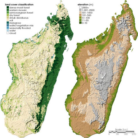
Left: Land cover map of Madagascar. Right: Topographical map of Madagascar. |
| Date |
June 24, 2004 (published) |
| Source |
http://earthobservatory.nasa.gov/Study/Chameleons/chameleons2.html |
| Author |
Robert Simmon, based on data provided by Ned Horning, American Museum of Natural History (left), and Socioeconomic Data and Applications Centre, Columbia University (right) |
Permission
( Reusing this file) |
NASA, public domain
|
Licensing
| Public domainPublic domainfalsefalse |
 |
This file is in the public domain because it was solely created by NASA. NASA copyright policy states that "NASA material is not protected by copyright unless noted". (See Template:PD-USGov, NASA copyright policy page or JPL Image Use Policy.) |
|
|
|
Warnings:
- Use of NASA logos, insignia and emblems are restricted per US law 14 CFR 1221.
- The NASA website hosts a large number of images from the Soviet/ Russian space agency, and other non-American space agencies. These are not necessarily in the public domain.
- Materials based on Hubble Space Telescope data may be copyrighted if they are not explicitly produced by the STScI. See also {{ PD-Hubble}} and {{ Cc-Hubble}}.
- The SOHO (ESA & NASA) joint project implies that all materials created by its probe are copyrighted and require permission for commercial non-educational use.
- Images featured on the Astronomy Picture of the Day (APOD) web site may be copyrighted.
|
File usage
The following pages on Schools Wikipedia link to this image (list may be incomplete):
SOS Children chose the best bits of Wikipedia to help you learn. SOS Childrens Villages is an international children's charity, providing a good home and loving family to thousands of children who have lost their parents. We also work with communities to help vulnerable families stay together and raise children in the best possible environment. You can help by sponsoring a child.


