
File:Sudan agriculture Landsat.jpg
| |
This is a file from the Wikimedia Commons. Information from its description page there is shown below.
Commons is a freely licensed media file repository. You can help. |
Transwiki approved by: w:en:User:Dmcdevit
This image was copied from wikipedia:en. The original description was:
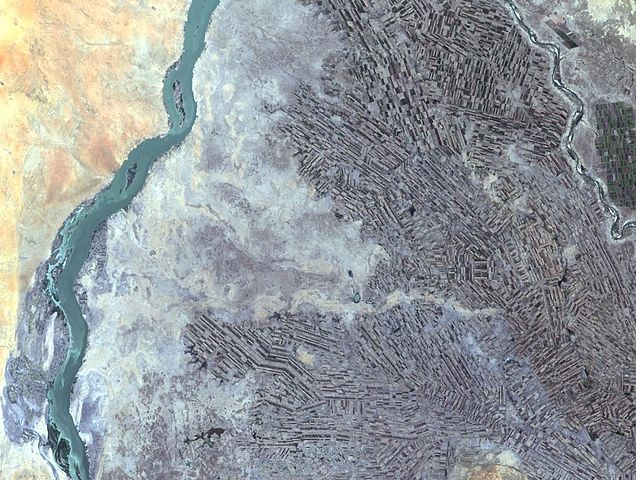
Farming along White and Blue Nile Rivers, near Khartoum, w:en:Sudan
In the Sahara Desert, along the White and Blue Nile rivers lies a thriving agricultural area. As seen in this Landsat 7 image, the farming patterns resemble French long farms, whose long, rectangular shapes allow each individual plot access to water from irrigation canals along the narrow side. The White Nile (left side of image) joins with the narrower Blue Nile (right side of image) a few miles further north at the city of Khartoum, Sudan, home to approximately 1 million of Sudan’s 33 million people. Sudan’s main crop is cotton, a very water-intensive crop for such an arid land. Surrounding Khartoum is the eastern Saharan Desert, noticeable as the reddish area in the upper left portion of the image.
http://landsat.usgs.gov/gallery/detail/384/
 |
This image is in the public domain because it contains materials that originally came from the United States Geological Survey, an agency of the United States Department of the Interior. For more information, see the official USGS copyright policy. български | català | Deutsch | English | español | eesti | suomi | français | galego | italiano | 한국어 | македонски | മലയാളം | Nederlands | polski | português | русский | Türkçe | 中文 | 中文(简体) | +/− |
|
Image description page history
| link | date/time | username | edit summary |
|---|---|---|---|
| http://en.wikipedia.org/w/index.php?title=Image:Sudan_agriculture_Landsat.jpg&redirect=no&oldid=158189774 | 03:38, 16 September 2007 | w:en:User:Dmcdevit | |
| http://en.wikipedia.org/w/index.php?title=Image:Sudan_agriculture_Landsat.jpg&redirect=no&oldid=158189774 | 03:15, 16 September 2007 | w:en:User:Dmcdevit | |
| http://en.wikipedia.org/w/index.php?title=Image:Sudan_agriculture_Landsat.jpg&redirect=no&oldid=57765040 | 20:47, 9 June 2006 | w:en:User:CmdrObot | |
| http://en.wikipedia.org/w/index.php?title=Image:Sudan_agriculture_Landsat.jpg&redirect=no&oldid=26746310 | 22:51, 28 October 2005 | w:en:User:Wikiacc | |
| http://en.wikipedia.org/w/index.php?title=Image:Sudan_agriculture_Landsat.jpg&redirect=no&oldid=26381707 | 21:21, 24 October 2005 | w:en:User:Brian0918 | (Farming along White and Blue Nile Rivers, near Khartoum, Sudan In the Sahara Desert, along the White and Blue Nile rivers lies a thriving agricultural area. As seen in this Landsat 7 image, the farming patterns resemble French long farms, whose long,) |
File usage
Learn more
Wikipedia for Schools brings Wikipedia into the classroom. SOS Childrens Villages helps more than 2 million people across 133 countries around the world. Help another child by taking out a sponsorship.