File:Haiti relief landing jan22.jpg

| |
This is a file from the Wikimedia Commons. Information from its description page there is shown below.
Commons is a freely licensed media file repository. You can help. |
| Description |
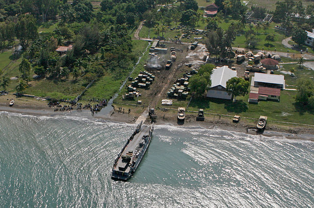
English: US Navy and Marines build a harbour landing facility near Port-au-Prince following the 2010 earthquake.
|
| Date | 03:49, 23 January 2010 (UTC) (23 January 2010 (original upload date)) |
| Source | Transferred from en.wikipedia; transferred to Commons by User:Leoboudv using CommonsHelper. (Original text : http://www.navy.mil/view_single.asp?id=80431) |
| Author | U.S. Marine Corps photo by Cpl. Theodore W. Ritchie. Original uploader was Fancy-cats-are-happy-cats at en.wikipedia |
| Permission ( Reusing this file) |
PD-USGOV-MILITARY-NAVY. |
|
Object location |
18° 33′ 48.60″ N, 72° 35′ 8.52″ W |
This and other images at their locations on: Google Maps - Google Earth - OpenStreetMap - Proximityrama | ( Info)18.5635;-72.5857 |
|---|
Licensing
| Public domainPublic domainfalsefalse |
 |
This file is a work of a sailor or employee of the U.S. Navy, taken or made as part of that person's official duties. As a work of the U.S. federal government, the image is in the public domain. |
 |
|
|
||
File usage
Metadata
| Image title |
A landing craft unit unloads at a compound outside Leogane, Haiti Jan. 20, 2010. The 22nd Marine Expeditionary Unit is a multi-mission capable force comprised of Aviation Combat Element, Marine Heavy Helicopter Squadron 461 (Reinforced); Logistics Combat Element, Combat Logistics Battalion 22; Ground Combat Element, Battalion Landing Team, 3rd Battalion, 2nd Marine Regiment; and its command element. (Official Marine Corps Photo by Cpl. Theodore W. Ritchie) |
|---|---|
| Camera manufacturer | Canon |
| Camera model | Canon EOS 30D |
| Author | Cpl. Theodore W. Ritchie |
| Exposure time | 1/3,200 sec (0.0003125) |
| F-number | f/8 |
| ISO speed rating | 400 |
| Date and time of data generation | 11:05, 20 January 2010 |
| Lens focal length | 24 mm |
| Orientation | Normal |
| Horizontal resolution | 300 dpi |
| Vertical resolution | 300 dpi |
| Software used | Adobe Photoshop CS3 Windows |
| File change date and time | 02:28, 21 January 2010 |
| Y and C positioning | Co-sited |
| Custom image processing | Normal process |
| Exposure mode | Auto exposure |
| White balance | Auto white balance |
| Scene capture type | Standard |
| Exposure Program | Aperture priority |
| Exif version | 2.21 |
| Date and time of digitizing | 11:05, 20 January 2010 |
| Shutter speed | 11.643859863281 |
| APEX aperture | 6 |
| Exposure bias | 0 |
| Metering mode | Spot |
| Flash | Flash did not fire, compulsory flash suppression |
| Colour space | sRGB |
| Focal plane X resolution | 3,959.3220338983 |
| Focal plane Y resolution | 3,959.3220338983 |
| Focal plane resolution unit | inches |
What is Schools Wikipedia?
All five editions of Schools Wikipedia were compiled by SOS Children's Villages. SOS Children's Villages helps more than 2 million people across 133 countries around the world. Have you heard about child sponsorship? Visit our web site to find out.
