Benghazi
Background to the schools Wikipedia
This Wikipedia selection is available offline from SOS Children for distribution in the developing world. Sponsor a child to make a real difference.
| Benghazi بنغازي Binġāzī |
|
|---|---|
|
|
|
| Coordinates: 32°07′N 20°04′E | |
| Country | |
| District | Benghazi |
| Area | |
| • | 16,809 sq mi (43,535 km2) |
| Population (2006) | |
| • Total | 670,797 |
| Area code(s) | 061 |
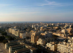
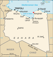
Benghazi or Bengasi (Arabic بنغازي, transliterated as Binġāzī; Turkish: Bingazi) is the second largest city in Libya and the main city (or capital) of the Cyrenaica region (or ex-Province). The wider metropolitan area (which includes the southern towns of Gimeenis and Suluq) is also a district of Libya. During the Kingdom era of Libya's history, Benghazi enjoyed a sort of joint-capital status (alongside Tripoli), possibly because the King used to reside in the nearby city of Al Bayda' and the Senussis (royal family) in general were associated with Cyrenaica rather than Tripolitania.
Benghazi continues to hold institutions and organizations normally associated with a national capital city. This creates a constant atmosphere of rivalry and sensitivities between Benghazi and Tripoli and by extension between the two regions (Cyrenaica and Tripolitania). The population of the entire district was 500,120 in 1995 (census) and has increased to 670,797 in the 2006 census.
Etymology
The city's present name, Benghazi, is derived from that of a pious benefactor of the city named Ghazi or "Sidi Ghazi," as the locals called him, who died about 1450. The city was renamed "Bani Ghazi" (which literally means Ghazi's sons or descendants). "Ghazi" literally means veteran in Islamic culture. A soldier who survives an important war or clash earns this title. Turkish "Bingazi" literally means "Thousand ghazis", but this must be the assimilation of the name in Turkish by using a homophonic word.
History
Ancient Greek colony
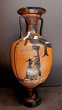
The Ancient Greek city that existed within the modern day boundaries of Benghazi was founded around 525 BCE and called Euesperides. It was probably founded by people from Cyrene or Barce on the edge of a lagoon which opened from the sea and was at the time may have been deep enough to receive small sailing vessels. The name was attributed to the fertility of the neighbourhood, which gave rise to the mythological associations with the garden of the Hesperides The ancient city existed on a raised piece of land opposite what is now the Sidi-Abayd graveyard in the Northern Benghazi suburb of Sbikhat al-Salmani (al-Salmani Marsh).
The city is first mentioned by ancient sources in Herodotus' account of the revolt of Barca and the Persian expedition to Cyrenaica in c.515 BCE (Before Common Era), where we learn that the punitive force sent by the satrap in Egypt conquered most of Cyrenaica and reached as far west as Euesperides. The oldest coins minted in the city date back to 480 BCE. One side of the coin has an engraving of Delphi. The other side is an engraving of a silphium plant, which once formed the crux of trade from Cyranaica because of its use as a rich seasoning and as a medicine. Its coinage suggests that it must have enjoyed an intermittent autonomy from Cyrene in the early fifth century, when the coins of Euesperides had their own types, distinct from those of Cyrene with the legend EU(ES).
The city was in hostile territory and was surrounded by inhospitable tribes. The Greek historian Thucydides mentions a siege of the city in 414 BCE by Libyan tribes who were probably the Nasamones. Euesperides was saved by the chance arrival of Spartan general Gylippus and his fleet, who were blown to Libya by contrary winds on their way to Sicily.
One of the Cyrenean kings whose fate is tragically connected with the city is Arcesilaus IV. The King used his chariot victory at the Pythian Games of 462 BCE to attract new settlers to Euesperides, where Arcesilaus hoped to create a safe refuge for himself against the resentment of his people in Cyrene. This proved totally ineffective, since when the King fled to Euesperides during the anticipated revolution (around 440 BCE), he was assassinated, thus terminating the almost two hundred year rule of the Battiad dynasty.
From an inscription found in modern Benghazi and dated around the middle of the fourth century BCE, we learn that the city had a similar constitution to that of Cyrene, with a board of chief magistrates (ephors) and a council of elders (gerontes). Later in the fourth century BCE, during the unsettling period which followed Alexander's death, the city backed the losing side in a revolt led by the Spartan adventurer Thibron; he was trying to create an empire for himself, but was defeated by the Cyreneans and their Libyan allies.
After the marriage of Ptolemy III to Berenice, daughter of the Cyrenean Governor Magas, around the middle of the third century, many Cyrenaican cities were renamed to mark the occasion. Euesperides became Berenice and the change of name also involved a relocation. Its desertion was probably due to the silting up of the lagoons; Berenice, the place they moved to, lies underneath Benghazi's modern city centre. The Greek colony had lasted from the sixth to the mid-third centuries BCE.
Romans
Modern Benghazi, on the Gulf of Sidra, lies a little southwest of the site of the ancient Greek city of Berenice or Berenicis. That city was traditionally founded in 446 BCE (different sources give different dates like 347 BCE or 249 BCE), by a brother of the king of Cyrene, but got the name Berenice only when it was refounded in the 3rd century BCE under the patronage of Berenice (Berenike), the daughter of Magas, king of Cyrene, and wife of Ptolemy III Euergetes, the ruler of Egypt. The new city was later given the name Hesperides, in reference to the Hesperides, the guardians of the mythic western paradise. The name may have also referred to green oases in low-lying areas in the nearby coastal plain. Benghazi later became a Roman city and prospered for 600 years. The city superseded Cyrene and Barca as the chief centre of Cyrenaica after the 3rd century CE and during the Persian attacks, but when the Arabs came, in 642-643, it had dwindled to an insignificant village among magnificent ruins.
Ottoman province
In the 1200s, the small settlement became an important player in the trade growing up between Genoese merchants and the tribes of the hinterland. In 16th century maps, the name of Marsa ibn Ghazi appears.
Benghazi had a strategic port location, one that was too useful to be ignored by the Ottomans. It was in 1578 that the Turks invaded Benghazi and it was ruled from Tripoli by the Karamanlis from 1711–1835, then it passed under direct Ottoman rule until 1911. Under Ottoman rule, Benghazi was the most impoverished of the Ottoman provinces. It had neither a paved road nor telegraph service, and the harbour was too silted to permit the access of shipping. Greek and Italian sponge fishermen worked its coastal waters. In 1858, and again in 1874, Benghazi was devastated by bubonic plague.
Italian invasion
In 1911, Benghazi was invaded by the Italians. The local population of Cyrenaica under the leadership of Omar Mukhtar resisted the Italian occupation. Cyrenaica suffered ruthless oppression, particularly under the fascist dictator Mussolini. About 125,000 Libyans were forced into concentration camps, about two-thirds of whom perished.
Heavily bombed in World War II, Benghazi was later rebuilt with the country's newly found oil wealth as a gleaming showpiece of modern Libya.
On 15 April 1986 US Airforce and Navy planes bombed Benghazi and Tripoli. President Ronald Reagan justified the attacks by claiming Libya was responsible for terrorism directed at the USA, including the bombing of La Belle discothèque in West Berlin ten days before.
Administrative divisions
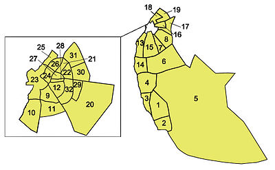
Benghazi is one of Libya's 22 shabiyahs (people's districts). Benghazi shabiyah is divided into 32 Basic People's Congress administrative divisions, in which the responsibilities of the corresponding political units of the same name fall. The official 32 Basic People's Congresses of Benghazi are:
|
|
|
|
Geography
Benghazi is one of the sub-regions of the area referred to as Cyrenaica, the others being the Jabal Akhdar and the coastal plain running east of Apollonia. Cyrenaica is surrounded by desert on three sides, hence in ancient times the most accessible civilisation was to the North, across the Mediterranean, in Crete and Greece, only 400 km away.
Benghazi is surrounded by the 'barr', arid steppe. The Jabal Akhdar, literally, 'the Green Mountain', just north of Benghazi, rises to the east. Here the vegetation and climate is more Mediterranean in feel with none of the desert landscapes found further south. A large section of the western Jabal Akhdar is taken up by the fertile Al Marj plain. Further east is the second level of the Jabal Akhdar, between 500 m and over 875 m above sea level, often thickly wooded and cut by ravines. Annual rainfall here, especially around Cyrene, can reach 500 mm. It was this fertile site northeast of Benghazi that the Greeks chose for their settlement. The soil in Benghazi is a rich red colour and very clayey. Sirocco winds are not uncommon in the city, and as such, many of Benghazi's smaller streets and buildings can be quite dusty.
To the north, below the steep cliffs of the plateau, lies a narrow belt of Mediterranean farmland. Olives and other mediterrenean fruits and vegetables are grown here. To the south, the forest and farmland gives way to juniper bush maquis and pre-desert scrub with some winter grazing.
As a district, Benghazi borders Al Hizam Al Akhdar, which surrounds it on land.
Climate
Benghazi has a warm semi-arid climate ( Köppen climate classification BSh). To the north of the city is the Mediterranean Jabal Al-Akdhar, and to the south the climate is desert like. Summers in Benghazi are hot and dry. Winters are mild with occasional rain. Annual rainfall is low at 268mm per year.
| Climate data for Benghazi | |||||||||||||
|---|---|---|---|---|---|---|---|---|---|---|---|---|---|
| Month | Jan | Feb | Mar | Apr | May | Jun | Jul | Aug | Sep | Oct | Nov | Dec | Year |
| Source: BBC Weather | |||||||||||||
Natural recreation and parks
Although Benghazi does not have a high percentage of green space per resident, there are a few public parks and green recreational areas in the city. Perhaps the most famous is the zoological garden and theme park in Al-Fuwayhat; the park is referred to locally as al-Bosco, a colloquial Italian name for zoo. The park is a combination of a zoo built during Italian rule (which contains wild cats, primates, elephants, birds and other animals) and a small theme park of electric rides, added later in the 1980s as part of a redevelopment of the entire site. It is one of the most popular parks in Benghazi, and is very busy on public holidays, as well as amongst school children and scouts on outings.
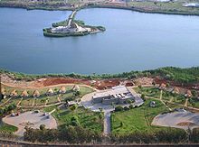
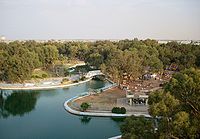
On Gamal Abdel Nasser Street is the 23rd of July Park, another large green space which faces the Tibesti Hotel and borders the waterfront. The park is popular amongst teenagers, and families on Thursday nights (as Friday is a day off work throughout Libya). Another large and popular park is al-Buduzira in North Benghazi on the al-'Uruba Road in al-Kwayfiya. The park surrounds a natural lake, and is more rugged in nature than the city parks. A section of al-Buduzira is also a water park with large slides, whilst the southern part of the park has picnic areas which are popular in the summers.
Economy
Benghazi is the principal city of Eastern Libya and is one of Libya's major economic centres. The city has an important port which is vital to the economy, as many foodstuffs and manufactured products need to be imported into Libya. Benghazi is also an industrial and commercial centre in Libya. Major manufactured goods include processed food, textiles, tanning, salt processing and construction materials, particularly cement; a large cement factory is located in al-Hawari. Food processing is based on local fish, imported goods, and the produce of irrigated coastal lowlands and the nearby Jabal al-Akdhar Mountains, including cereal, dates, olives, wool and meat.
Finance is also important to the city's economy with the Libyan Bank of Commerce and Development maintaining branches in Benghazi; its headquarter is a high office tower on Gamal Abdel Nasser Street in el-Berka. Other large banks include the Central Bank of Libya office in the city centre as well as others. It is the oil industry however that drives the city's commerce. Large national companies such as the Al-Brega Oil Marketing Company and the Arabian Gulf Oil Company are important to the city's economy and employ many people. An increase in consumer prices has been coupled with an increase in the importance of the retail sector to the city's economy. In recent years, international franchises such as United Colors of Benetton, H&M and Nike have opened in Benghazi.
Tourism is still in its very early stages in Libya. The industry is however growing in importance in Benghazi. The majority of tourists that visit Eastern Libya use Benghazi as a base for which to explore the Greek ruins in Cyrene or desert excursions south in Kufra. The two main hotels in the city are the Tibesti Hotel and Uzu Hotel, and several other hotels have opened in recent years to cater for increased demand. Handicrafts are found in the many souks in the city, but are of little significance to the economy.
A good connection of speedways and flyovers were built by Skanska in the decades after the Libyan revolution in 1969; this has made the transport of goods between Benghazi and other cities easier. Air transport from the city is via Benina International Airport; numerous daily flights leave for the capital Tripoli and connections are also available to other African, Asian and European cities.
Demographics
As with other cities in Libya, there is a reasonable amount of ethnic diversity in Benghazi. The people of eastern Libya, Benghazi included, have in the past always been of predominantly Arab descent. In recent times, however, there has been an influx of African immigrants into Benghazi. There are also many Egyptian immigrants in Benghazi. A small Greek community also exists in Benghazi. The Greek island of Crete is a short distance from Benghazi and many families in Benghazi today bear Cretian surnames.
The overwhelming majority of Libyans in Benghazi are of Arab descent. In the 11th century, the Sa'ada tribe from the Bani Salim migrated to Cyrenaica; each sub tribe from the Sa'adi historically controlled a section of Libya. Benghazi and its surrounding areas were controlled by the Awaqir and Barghathi tribes as well as immigrants from Misrata. In modern times, Benghazi has seen a lot of Libyans from differents parts of the country move into the city, especially since the Kingdom era. Many came to Benghazi from Misrata (About 60% of the population have roots from Misrata).
Education
Education in Benghazi, as is throughout Libya, is compulsory and free. Compulsory education continues up until ninth grade. There are many public primary and secondary schools scattered throughout the city as well as some private and international schools. University education is also free for all Libyan citizens in Benghazi. The largest university, Garyounis University, was founded in 1955. The country's largest library containing over 300,000 volumes is affiliated with the University. Benghazi is also home to the country's first university, the former Al-Jami'a al-Libiya.
Religion
The predominant religion in Benghazi is Islam. Practically all of the city's inhabitants are Sunni Muslims. The city is fairly conservative, and nearly all women wear a hijab (headscarf), even more so than in the capital Tripoli. During Islamic holidays such as Ramadhan, most abstain from food, and restaurants are usually empty during the day (with the exception of some foreign workers). Alcohol is forbidden in Benghazi and throughout Libya, in accordance with Islamic principles. The conservative Islamic nature of Benghazi creates a strong sense of family life in the city. Practically all teenagers and young adults live at home until they get married. In the past, virtually everybody in Benghazi adhered to the traditional Maliki school of religious law. In recent years however, with the spread of literalist Islamic television channels, more and more people are beginning to practice schools of thought popular in Saudi Arabia such as Wahabbism. Consequently, it is not uncommon to see woman wearing black niqabs and men with full beards in Benghazi.
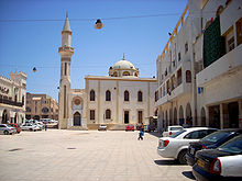
There is also a small foreign Christian community in the city. The Roman Catholic Franciscan Church of the Immaculate Conception serves Benghazi's Catholic community of roughly 4000. For Egyptian Copts, there is a Coptic Orthodox church with two serving priests. Jews lived in Benghazi as they did elsewhere in Libya, from Roman times until 1967 when most were airlifted out. Few remain today. For Muslims, there are many mosques throughout Benghazi; the oldest and best known such as the Atiq and Osman mosques are located in and around the medina.
Cityscape
The city is divided into many neighbourhoods, some of which were founded during Italian Colonial rule and many which have developed as a result of modern urban sprawl. The different neighbourhoods vary in their levels of economic prosperity, as well as their cultural, historic and social atmosphere. Generally, the city is roughly divided into the following areas: Central Benghazi (colloquially referred to as al-Blaad by locals) - includes the medina, and the old quarter, Central Districts which circle the downtown - Al-Sabri, Sidi Abayd, Sidi Hsayn, Al-Berka, Al-Salmani, Al-Hadaa'ik, Al-Fuwayhat and Al-Keesh, Central Suburbs - Al-Laythi, Bu Atni, Al-Quwarsha, Al-Hawari, Coastal Districts - Al-Kwayfiya (North), Garyounis, Bu-Fakhra and Jarrutha (South), and the Distant Suburbs - Gimeenis, Benina and Sidi Khalifa.
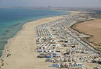
Central Benghazi is where the majority of Benghazi's historical monuments are located, and has the city's most popular tourist attractions. Virtually all of Benghazi's theatres, libraries, best clothing stores, markets and old mosques can be found there. The Italian quarter is also located in the centre. The central districts are mostly residential and commercial areas such as Sidi Hsayn. The central suburbs are almost entirely residential and more like little towns in their own right; Al-Quwarsha is a good example of this. The coastal districts (especially the southern districts) are where Benghazi's beaches can be found. Some sections have become more popular as residential areas in recent years (such as Qanfuda). These areas are still primarily recreational however, and many beach condominium resorts (known locally as chalets) have been built in previous years such as those at al-Nakheel beach, and the Nayrouz condominiums.
Culture
Benghazi is one of the cultural centres of Libya and is a base for tourists, visitors and academics in the region. Throughout its history, Benghazi has developed with a certain level of independence from the more Maghreb oriented capital Tripoli. This has influenced the city, and as such, the cultural atmosphere in Benghazi is more Arab in nature than that in Tripoli. An influx of African immigrants as well as Egyptian, Iraqi, Palestinian, Sudanese and Syrian immigrants have also influenced the city's culture to a certain extent in recent years.
The city centre contains a few local theatres, as well as the Dar al-Kutub National Library in Al-Funduq, where the works of popular local novelists like Sadeq Naihoum and Khalifa al-Fakhri can be found. Different architectural styles attest to the different empires that have controlled the city throughout history. Sport is also important in the city; two of Libya's most successful football clubs are based in Benghazi.
Architecture
There are a variety of architectural styles in Benghazi, which reflect the number of times the city has changed hands throughout its history. Arab, Ottoman and Italian rule have influenced the different streetscapes, buildings and quarters in Benghazi.
Ancient architectural remains of the Greek and later Roman settlement of Berenice can be found by the Italian lighthouse. There is a trace of the 3rd century wall built by the Greeks, four Roman peristyle houses, six wine vats. A Byzantine church also exists on the site, with a mosaic still intact. These ruins formed the northern part of the ancient city, which extended south and east but now lies buried beneath the modern city.
The next oldest section of the city is the medina, which began to grow sometime under Medieval Arab rule, and is still intact today. This quarter stretches out from the Northern shores of the harbour, and covers an area roughly bounded by Ahmed Rafiq al-Mahdawi Street to the North-west, al-Jezayir Street to the South-east and the 23rd of July Street to the South-west. The heart of the medina is Maydan al-Hurriya (Freedom Square); to the northeast of this is the covered Souq al-Jareed.
The largest Ottoman architectural monument in Benghazi is the late 19th-century Ottoman palace in El-Berka; built during the rule of Rashid Pasha II. The front elevation was completed in 1895, whilst the side sections were added later during Italian rule. The white and green structure houses 360 rooms; and is on a tract of land where Gamal Abdel Nasser Street meets al-Saqzali Street; south of the 28th of March football stadium.
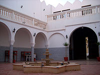
The house of Omar Pasha Mansour El Kikhia, an Ottoman Pasha from a prominent Benghazi family, represents a good example of Ottoman residential architecture with several balconies, stone archways, and an open courtyard containing a fountain. The home has recently been restored, remodeled, and converted into the Bait-al Medina al-Thaqafi museum.
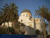
Benghazi came under Italian rule in the early part of the 20th century. Some examples of Italianate, as well as modernist colonial architecture from this period remains today. Under the governorships of Generals Ernesto Mombelli and Attilio Teruzzi in the 1920s, the buildings commissioned in Benghazi had an eclectic architectural language that embodied a Western conception of Eastern architecture. An example of this is the Municipal palace built in 1924, which stands in Maydan al-Hurriya (Freedom Square). The building combines Moorish arches with Italianate motifs on the facade. The largest colonial building from this period is the former Catholic Cathedral in Maydan El Catedraeya (Cathedral Square), which was built in the 1920s and has two large distinct domes.
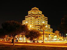
Benghazi was heavily bombed during World War II, and so the majority of buildings in the city are examples of modern or contemporary architecture. The central business district was built mostly in the 1960s and 1970s with Libya's new found oil wealth. The highest building in Benghazi is the Tibesti Hotel on Gamal Abdel Nasser Street built in 1989. Another prominent example of modern architecture in Benghazi is the Da'wah al-Islamiyah Building, which has a series of distinctive cubes piled in the shape of a pyramid.
Sport
Benghazi is the second largest city in Libya, and as such has some of the best sports facilities in the country. The city has various sports facilities of differing standards, such as football stadia, beach clubs where many water sports are played, as well as several other public and private sporting facilities. Benghazi has hosted many national sporting events throughout the years, as well as more significant international events such as the African Cup of Nations.
Football is the most popular sport in Benghazi, and two of the country's most successful football clubs, Al-Nasr and Al-Ahly Benghazi are based in the city. The two teams have won the Libyan Premier League five teams between them. The most important football event that took place in Benghazi was the 1982 African Nations Cup. The city hosted six group games and a semifinal in the March 28th Stadium, Libya's second largest stadium. The city will very likely be the scene of more games when Libya hosts the African Nations Cup again in 2014.
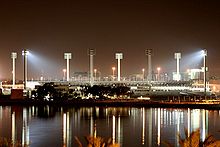
The largest sporting centre in Benghazi is the Medina al-Riyadhia (Sports City). The complex is situated just south of the city centre, and houses the March 28th football and athletics stadium, and a basketball stadium; Benghazi's basketball stadium will host some of the matches of the 2009 FIBA Africa Championship. The complex also has a sports hall for indoor sports, a tennis stadium and several small tennis courts. The facility was built in the 1950s and is therefore quite outdated; the stadia have nonetheless undergone maintenance work in recent years. Sports City was recently closed down for a complete redevlopment of the site. As of 2009, the March 28th Stadium is undergoing demolition work, and a new 45,000 all seater stadium will be constructed in its place. A second smaller stadium will be built on-site, and the entire site will undergo redevelopment before its reopening in 2011, and its use in the 2014 African Nations Cup.
Benghazi is a coastal city, and its beaches are an important location for sporting activities. The coast at Jeliana is home to the Milaha Beach Club amongst others. Wind surfing and swimming are two of the most popular water sports. There are also several contact sport clubs in the city - judo and taekwondo are popular mens sports in Benghazi, but most recently rugby sevens has seen great success, with three clubs to its name. Gyms have also become more popular in the city in recent years, because of a greater concern for healthy living amongst Libyans.
Transport
Work started in September 2008 on a new railway network that will connect to major cities of western Libya at Surt. Russian Railways is responsible for the 3 year contract. In the future, a rail link may be built to both Tunisia and Egypt forming a North African coastal rail netwrork.
