Diego Garcia
Background Information
This Wikipedia selection is available offline from SOS Children for distribution in the developing world. SOS mothers each look after a a family of sponsored children.
| Diego Garcia | |||
|---|---|---|---|
| IATA: NKW – ICAO: FJDG | |||
| Summary | |||
| Airport type | Naval Support Facility | ||
| Owner | United Kingdom | ||
| Operator | United States Navy, Royal Navy, Royal Marines | ||
| Location | Diego Garcia, Chagos | ||
| Built | 1980s | ||
| In use | 1971 - present | ||
| Elevation AMSL | 9 ft / 3 m | ||
| Coordinates | 7°18′48″S 72°24′40″E | ||
| Runways | |||
| Direction | Length | Surface | |
| ft | m | ||
| 13/31 | 12,003 | 3,659 | Concrete |
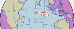
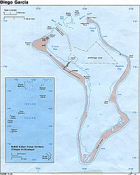
Diego Garcia is an atoll in the middle of the Indian Ocean, about 1,600 km (1,000 mi) south off India's and Sri Lanka's southern coasts. It is the largest atoll by land area in the Chagos Archipelago. It is part of the British Indian Ocean Territory (BIOT), a British overseas territory.
Since the enforced depopulation of Diego Garcia in the years leading up to 1973, it has been used as a military base by the United Kingdom and the United States. It has one of five ground antennas assisting in the operation of the Global Positioning System, the others being on Ascension Island, Hawaii, Kwajalein and in Colorado Springs.
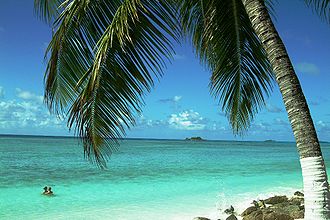
It is covered in luxuriant tropical vegetation, with little sign of the copra and coconut plantations that once covered it. It is 60 kilometres (37 mi) long, with a maximum elevation of 6.7 metres (22 ft), and nearly encloses a lagoon about 19 kilometres (12 mi) long and up to 8 kilometres (5.0 mi) wide. Depths in the lagoon extend to 30 metres (98 ft), and numerous coral heads form hazards to navigation. Shallow reefs surround the island on the ocean side. The channel and anchorage area are dredged, while the old turning basin can also be used.
Geography
The atoll forms a nearly complete rim of land around a lagoon, enclosing 90 percent of its perimeter, with an opening only in the north. The main island is the largest of about sixty islands which form the Chagos Archipelago. Besides the main islands, there are three small islets at the mouth of the lagoon in the north:
- West Island (3.4 ha/8.4 acres)
- Middle Island (6 ha/14.8 acres)
- East Island (11.75 ha/29 acres)
The total area of the atoll is 174 km² (66 mi²) according to , of which 30 km² (12 mi²) are land, 17 km² (6.5 mi²) peripheral reef and 124 km² (48 mi²) are lagoon.
Climate
Annual rainfall averages 260 cm (102 in), with the heaviest precipitation from October to February. August, the driest month, averages 100 mm (4.2 in). Temperatures are generally close to 30 °C (86 °F) by day, falling to the low 20s °C (70 °F) by night. Humidity is high throughout the year. The almost constant breezes keep conditions reasonably comfortable.
Diego Garcia is at risk from tropical cyclones. The surrounding topography is low and does not provide an extensive wind break. Since the 1960s the island has not been seriously affected by a severe tropical cyclone, even though it has often been threatened. The maximum sustained wind associated with a tropical cyclone in the period 1970-2000 was approximately 40 knots (75 km/h).
The island was somewhat affected by the tsunami caused by the 2004 Indian Ocean earthquake. Service personnel on the western arm of the atoll island reported only a minor increase in wave activity. The island was protected to a large degree by its favourable ocean topography. About 80 km (50 mi) east of the atoll lies the 650 km (400-mile) long Chagos Trench, an underwater canyon plunging more than 4,900 m (16,000 ft). The depth of the trench and its grade to the atoll's slope and shelf shore makes it more difficult for substantial tsunami waves to build before passing the atoll from the east. In addition, near shore coral reefs and an algal platform may have dissipated much of the waves' impact. A biological survey conducted in early 2005 indicated erosional effects of the tsunami wave on Diego Garcia and other islands of the Chagos Archipelago. One 200 to 300 m stretch of atoll shoreline was found to have been breached by the tsunami wave, representing approximately 10 percent of the eastern arm. A biological survey by the Chagos Conservation Trust reported that the resulting inundation additionally washed away shoreline shrubs and small to medium size coconut palms.
On November 30, 1983 a magnitude 7 earthquake 55 km (34 mi) northwest of the island caused a small tsunami resulting in a 1.5 m (5 ft) rise in wave height in the lagoon, causing some damage to buildings, piers and the runway.
History
Portuguese explorers discovered Diego Garcia in the early sixteenth century. The island's name is believed to have come from either the ship's captain or the navigator on that early voyage of discovery.
The islands remained uninhabited until the 18th century when the French established copra plantations using slave labour. Diego Garcia became a possession of the United Kingdom after the Napoleonic wars, and from 1814 to 1965 it was a dependency of Mauritius.
In 1914, the island was visited by the German cruiser SMS Emden.
In 1965, the Chagos Islands, which include Diego Garcia, were detached from Mauritius to form part of the British Indian Ocean Territories (BIOT). In 1966 the crown bought the islands and plantations, which had been under private ownership and which had not been profitable with the introduction of new oils and lubricants. In 1971, the plantations were closed because of the agreement between the United Kingdom and the United States to make Diego Garcia available to the U.S. as a military base. No payment was made as part of this arrangement, although it has been claimed that the United Kingdom received a US$14 million discount on the acquisition of Polaris missiles from the United States. The agreement forbids any other economic activity on the island.
Until 1971 Diego Garcia had a native population of 2,000 Chagossians or Ilois, descendants of Indian workers and African slaves who had been brought to the island in the eighteenth and nineteenth centuries to work on the coconut and copra plantations. They lived in three settlements: East Point, the main settlement on the eastern rim of the atoll; Minni Minni, 4.5 km (2.75 mi) north of East Point; and Pointe Marianne, on the western rim. The islanders were forcibly depopulated to the Seychelles and then to Mauritius using controversial techniques by the UK government. Since their expulsion the Chagossians have continually asserted their right to return to Diego Garcia. In April 2006, 102 Chagossians were allowed to visit Diego Garcia for a week, to tend to graves and visit their birthplaces. For a good general history of the Islands and what happened to the Ilois, refer to The Minority Rights Group Report No 54 - 'Diego Garcia: a contrast to the Falklands.
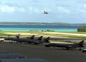
Diego Garcia is home to a military base jointly operated by the United States and the United Kingdom. It is a naval refuelling and support station and the home of Maritime Prepositioning Ship Squadron Two, the naval unit responsible for the readiness of the ships in Military Sealift Command Prepositioning Program in the Indian Ocean, a vital strategic asset to the United States. It has an air base that primarily supported land-based U.S. Navy P-3 Orion maritime patrol aircraft during the Cold War. Since 11 September 2001, in addition to P-3 aircraft, it has also supported some of the largest military aircraft. U.S. Air Force B-52s, B-1Bs and B-2s, as well as various aerial refueling tanker aircraft have been deployed to Diego Garcia to execute missions. During the 1991 Gulf War, Diego Garcia was home to the 4300th Bomb Wing (Provisional), made up of B-52G bombers from the former Loring AFB, Maine and other B-52G bases. It was also used in support of military missions in Afghanistan during Operation Enduring Freedom, and to Iraq again during the 2003 invasion. High-tech portable shelters to support the B-2 bomber were built on the island before the 2003 invasion of Iraq. The B-52s, B-1s and B-2s deployed to Diego Garcia in anticipation of the second Iraq War carried out the initial aerial bombardment on Baghdad on March 22, 2003. Some of these bombers dropped GPS guided bombs and laser guided 1,905 kg (4,200 lb.) bunker busters in " decapitation strikes" intended to kill Saddam Hussein and other Baath Party officials. Although they now primarily deploy to Al Udeid Air Base in Qatar, Diego Garcia still remains a regular deployment site for U.S. Navy P-3C Orion maritime patrol aircraft.
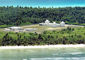
The base is part of the U.S. Space Surveillance Network, with a three-telescope GEODSS station, and is a NASA Space Shuttle emergency landing site.
Neither the U.S. nor the UK recognises Diego Garcia as being subject to the African Nuclear Weapons Free Zone Treaty, though the rest of the Chagos Archipelago is included, suggesting they wish to maintain the freedom to base nuclear weapons there.
The agreement between the UK and U.S. for the U.S. to use the island as a military base was made in 1966. It runs until 2036, but either government can opt out of the agreement in 2016.
Construction and maintenance of the base's communications equipment, fuel facilities and military hardware are done strictly by military contractors, and inventories of that weaponry are classified. No service-member family dependents are allowed. In 2001, the U.S. Department of Defense said that there were more buildings on Diego Garcia (654) than military personnel.
Politics
In 2000 the British High Court upheld the claims of the islanders that the Ordinance which had been enacted to ensure their removal (although it was never in fact invoked for that purpose) was unlawful. The then Foreign Secretary, Robin Cook, did not appeal. In 2002, the UK Parliament enacted legislation which gave all Chagossians the right to obtain British citizenship. granted the islanders the right to return to the Archipelago and granted them UK citizenship. In 2002, the islanders and their descendants, now numbering 4,500, returned to court requesting compensation, after two years of delays by the British Foreign Office. The Chagossians began proceedings to seek additional compensation payments from the British Government (they had been granted £650,000 compensation on removal in the 1970s, and a further £4 million in the early 1980s). The High Court and Court of Appeal upheld the Government's position that the compensation already paid was fair and lawful, and struck down the Chagossians claims for additional payments. Subsequently, on June 10, 2004, the British government enacted two Orders-in-Council re-establishing immigration controls on the islands and effectively banning the islanders from returning home, reversing the 2000 court decision. Some of the Chagossians are making return plans to turn Diego Garcia into a sugarcane and fishing enterprise as soon as the defence agreement expires, and there have been discussions about the development of a commercial tourism industry on the islands, which may raise environmental concerns. A few dozen other Chagossians are still fighting to be housed in the UK, although they have the same rights as all British citizens.
On May 11, 2006, the High Court ruled that the 2004 Orders-in-Council were unlawful, and that the Chagossians were entitled to return to the Chagos Archipelago. This judgment was upheld by the Court of Appeal on May 23, 2007. The British Government have appealed this decision to the House of Lords, and the hearing will be in late June 2008 and early July 2008.
Prison site allegation
Human rights groups claim that the military base is used by the U.S. government for the controversial extraordinary rendition of prisoners. This claim was supported by the Council of Europe in June 2007. The British Foreign Secretary Jack Straw stated in Parliament that U.S. authorities have repeatedly assured him that no detainees have passed in transit through Diego Garcia or have disembarked there. In October 2007 the all-party Foreign Affairs Committee of the British Parliament announced that it would launch an investigation of the claims, which it is reported were twice confirmed by General Barry McCaffrey.
On October 19 2007 The Guardian reported: "The all-party foreign affairs committee is to examine long-standing suspicions that the agency has operated one of its so-called ' black site' prisons on Diego Garcia..." The Guardian quoted British Member of Parliament Andrew Tyrie, "Time and time again the UK government has relied on US assurances on this issue, refusing to examine the truth of these allegations for themselves. It is high time our government took its head out of the sand and looked into these allegations."
Rendition admission by F.O.
On February 21 2008, British Foreign Secretary David Miliband admitted that two US extraordinary rendition flights refueled on Diego Garcia in 2002. Further, it has been implied that these actions constituted a direct breach of the treaty between the US and the UK concerning Diego Garcia.
Further allegations from U.N. Official
Manfred Novak, the United Nations' special rapporteur on torture, says that credible evidence exists supporting allegations about the use of Diego Garcia as a prison black site for alleged terrorists.
Clara Gutteridge, an investigator with human rights group Reprieve, states that US-operated ships moored outside the territorial waters of Diego Garcia were used to incarcerate and torture detainees.
Arrests
On 12 March 2008, The Guardian reported that two British protesters had been arrested for "entering the waters [of Diego Garcia] illegally".
Strategic importance
During the Cold War era, the United States was keen on establishing a military base in the Indian Ocean. Because of Diego Garcia's proximity to India, a potential ally of the Soviet Union, the United States saw the island as a strategically important one. U.S. military activities in Diego Garcia have caused friction between India and U.S. in the past. Various political parties in India repeatedly demanded that the U.S. dismantle the military base as they saw U.S. naval presence in Diego Garcia as a potential threat to India's dominance of the Indian Ocean.
After the end of the Cold War, relations between India and U.S. improved dramatically. Diego Garcia was the site of several naval exercises between the U.S. and Indian Navy held between 2001 and 2004.
Diego Garcia is also located relatively close to the Middle East, and experienced rapid military build-ups during the beginnings of the Iranian revolution and the Iraqi invasion of Kuwait.
Diego Garcia has several current missions. U.S. Air Force bombers and AWACS surveillance planes operate from the 3,650 m (12,000 ft) runway, and the USAF Space Command has built a satellite tracking station and communications facility.
The atoll shelters the 14 ships of Marine Prepositioning Squadron Two. These ships carry the equipment and supplies to support a major armed force with light tanks, armored personnel carriers, munitions, fuel, spare parts and even a mobile field hospital. This equipment showed its necessity during the Persian Gulf War, when the Squadron quickly delivered its equipment to Saudi Arabia. There, soldiers flown on air transports from U.S. and European bases quickly unloaded and deployed the pre-positioned material.
Pre-positioned vessels
There are five cargo vessels that each carry Marine Corps supplies sufficient to support a Marine Air-Ground Task Force for 30 days.
- MV Anderson
- MV Baugh
- MV Bonnyman
- MV Hauge
- MV Phillips
The four combat force ships provide rapid-response delivery of U.S. Army equipment to ground troops. Three are Lighter aboard ships (LASH) which carry barges called Lighters that contain Army ammunition to be ferried ashore.
- MV American Cormorant
- SS Green Harbour, (LASH)
- SS Green Valley, (LASH)
- MV Jeb Stuart, (LASH)
Five logistics vessels service the rapid delivery requirements of the U.S. Air Force, U.S. Navy and Defense Logistics Agency. There are two Air Force container ships for munitions, missiles and spare parts; a 500-bed hospital ship, and three floating storage and offloading units assigned to Military Sealift Command supporting the Defense Logistics Agency, including an offshore petroleum discharge system (OPDS) tanker ship.
- MV Buffalo Soldier, container
- MV Fisher container
- MV Green Ridge, hospital
- USNS Henry J. Kaiser, tanker
- SS Potomac, OPDS tanker
GPS
Diego Garcia is one of the five control bases for the Global Positioning System, operated by the US military. The US Air Force also has monitoring stations in Hawaii, Kwajalein, Ascension Island, and Colorado Springs, Colorado. The stations synchronise and update the atomic clocks on the 24 orbiting satellites that emit the signals used by GPS receivers.
Space Shuttle
The island is one of 33 emergency landing sites worldwide for the United States Space Shuttle. None of these facilities have been used for a Shuttle landing.
Cargo service
Since 2004 the MV Baffin Strait, often referred to as the "DGAR shuttle," has been chartered to deliver 250 containers each month from Singapore to Diego Garcia. The ship carries everything from fresh food to building supplies to aircraft parts, delivering more than 200,000 tons of cargo to the island each year." On the return trip to Singapore she carries recyclable metals.
In 2004 TransAtlantic Lines outbid Sealift Incorporated for the transport contract between Singapore and Diego Garcia. The route had previously been serviced by Sealift Inc.'s MV Sagamore, manned by members of American Maritime Officers and Seafarers' International Union. TransAtlantic Lines reportedly won the contract by approximately 10 percent, representing a price difference of about US$2.7 million.
The Baffin Strait's current charter runs from January 10, 2005 to September 30, 2008 at a daily rate of US$12,550 under contract number N00033-05-C-5500.
Wildlife
The island is a haven for several types of crab; hermit crabs overrun the jungle at night. The extremely large 4 kg coconut crab, or "robber crab" is found here. There is a large number of red crabs everywhere in the island though it is not known to which species they belong. They can be seen everywhere (tents, showers, laundry rooms, runway, etc.) The island hosts birds from many different regions, including Indian Barred Ground Dove ( Geopelia striata), Turtle Dove ( Streptopelia picturata), Indian Mynah ( Acridotheres tristis), Madagascar Fody ( Foudia madagascariensis), and imported chickens ( Gallus gallus).
All the flora and fauna are protected, and it is even unlawful to be in possession of a dead coconut crab. Hefty fines are levied against violators.
Diego Garcia was designated a Ramsar Site on July 4, 2001 (354 km2).
